1451m - 21.7 km (1695m - 28.3 km - L’Authion) (Lantosque (D73))
1591m - 30 km (1835m - 36.4 km - L’Authion) (St-Jean la Rivière)
1746m - 40.1 km (1990m - 46.7 km - L’Authion) (Plan du Var/Pont Durandy)
1526m - 28 km (1770m - km - L’Authion) (Sospel)
1540m - 30.5 km (1802m - 37.1 km - L’Authion) (L’Escarène)
1540m - 31 km (1802m - 37.7 km - L’Authion) (L’Escarène via St. Roch)
1849m - 40.5 km (2093m - 47.1 km - L’Authion) (Contes)
910m - 18.6 km (1172m - 25.3 km - L’Authion) (Col St. Roch)
893m - 19.1 km (1154m - 25.7 km - L’Authion) (Pas de l’Escous)
1615m - 26.6 km (1614m - 24.2 km - L’Authion) (Cairos forest road)
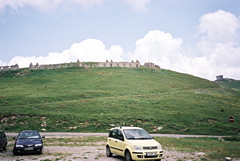
From the west one climbs the D70 from Camp de Milo (500m) via La Bollène-Vésubie and Col de Turini (1606m) to the pass which is located where the 9 km one-directional circle road up to L’Authion starts and ends. The L’Authion is the first asphalted road above 2000m from the south in the Alps and could be climbed almost without any descent all the way from Nice. The loop road first descends to 1779m and then climbs steeply to the high point (2024m).
From the southeast you climb from Sospel (363m) the D2566 via Col de Turini to the pass. From the south you climb D21 from Lucéram (650m) via Pas de l’Escous (1008m), Baisse de la Cabanette (1371m) and Col de Turini to the pass or via D2566 and Col de Saint-Roch (990m), Baisse de la Cabanette (1371m) and Col de Turini to the pass. One would then likely have started 6.4 km further down at L’Escarène (361m).
You could also start the southern climb in Contes (192m) and climb the D15 via Coaraze (619m) to Col de Savel (968m), Col St. Roch and take the D2566 to Baisse de la Cabanette and continue to the pass. (It is roughly 140m of climbing in the ups and downs after Coaraze.) The Peïra Cava road reaches 1618m before Col de Turini. From Col de Turini on the D68 to the pass (3.8 km), you will also climb the earlier Baisse de Camp d’Argent (1737m). – Lots of passes and roads in this region!
You could also reach, as I did, this pass via one of two different gravel roads and meet this pass on the descent from the one-directional loop at the L’Authion. These gravel roads meet at one point (1791m) on the loop road. The start for both roads could be down where the northern climb up Col de Brouis starts in the Roya valley. The northern gravel road could also be climbed from higher up in the Roya valley just below Fontan via Ste Claire (asphalted but steep, 7.8 km), which was the road I took. The gravel road from Ste Claire is very good up to Baisse de Colla Bassa (1348m) and not steep. Here you meet another gravel road and the road is here a bit less easy to ride up, but it improves a little again when getting closer to the asphalt road.
Great views on the circle road, but some sections on the approach roads are likely the nicest parts. (Photo is taken of the fort ruins near the highest point on the L’Authion circle road.) See also the Baisse de Peïra Cava (1508m) close to the Peïra Cava road.
[FR-06-1889, BIG 328]