1283m - 28.8 km (Val Pesariis/Comeglians)
1133m - 21.8 km (Borgo Tre Ponti); 1140m - 22.5 km (Ponte Nuovo)
867m - 16.5 km (Campolongo)
[IT-BL-1801]
|
Height | Climbing height - length |
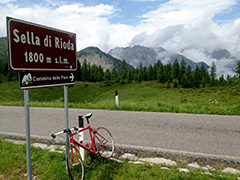
| 1801m (road height 1807m) |
1235m - 24.4 km (Ampezzo); 1527m - 30.3 km (south via Passo del Pura) 1283m - 28.8 km (Val Pesariis/Comeglians) 1133m - 21.8 km (Borgo Tre Ponti); 1140m - 22.5 km (Ponte Nuovo) 867m - 16.5 km (Campolongo) |
|
| Difficulty | Beauty | |
| 3-4 (5) South; 4 (5) South (via Passo del Pura); 3 (5) East | 4 (5) | |
| How to get there | Sella di Rioda were recently asphalted (late 2003 or 2004). This pass is close to Sella Ciampigotto/Valico di Cima Ciampigotto (1790m) and on the same road as Sella di Razzo (1758m), however the sign for the Razzo pass is placed on the Ciampigotto road (which was asphalted long ago). The southern climb starts in Ampezzo (568m). There are some steeper parts above Sauris. The really hard climb up here would be to start just west of Ampezzo (725m) and first climb the Passo del Pura/Pas dal Pure (1431m) and thereafter continue on the road from Ampezzo to the pass. The climb from Comeglians (524m) is gradual and becomes steeper toward the end. Sella di Rioda is close to the highest point on the Sauris road (you will see a dirt track leaving of east here). | |
| Other comments | There is a restaurant at the Sella Ciampigotto pass (which was very popular for lunch when I was there in 2000). The road over Passo del Pura is quite nice and has a quite demanding south side with serpentines all the way up. (8.1 km from Ampezzo road turn-off and 7 km down to Diga del Maina (982m)). Sauris/Zahre is an enclave where some still speak a kind of German (the city used to be very isolated before the road from Ampezzo was built. The northern climb from Campolongo (940m) via Forcella Lavardêt (1542m) (where one joins the road from Comeglians to the pass), is not possible as this road was destroyed long ago and is still in such a state that it could not be used with a road bike (it is only a jeep track for several kilometres, from what I have heard). [IT-BL-1801] |
|
| Map |
||