502m - 21 km (Briançon north)
399m - 16.2 km (Clarée valley)
725m - 23.1 km (Oulx)
1412m - 46.1 km (Susa)
This pass and the slightly higher Le Mauvais Pas (1779m) are only 2.2 km apart on each side of the flat pass stretch. This pass is actually the lowest pass across the Western Alps. It is not used as much as the nearby Col de Montgenèvre/Colle del Monginevro (1851m) since it is only 71m less high and the Montgenèvre pass has a wide smooth road with easy gradients and is a much more direct link between France and Italy.
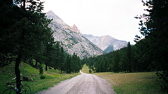
The easiest climbing starts from France in the highest town in the Alps, Briançon (1204m or 1260m), or further up on the road at the second of two alternative roads into Vallée de la Clarée (1389m) if coming down here from the Col de Montgenèvre. The climb only becomes a little steep when turning off the road through Vallée de la Clarée to Névache before reaching Névache at 1583m. From here a slightly rough and narrow asphalt road climbs through woods and in short time reaches the pass. There are no houses along this road and only an abandoned custom house at the top.
The climb via Bardonècchia (1258m) from Oulx (1067m) in the north is much more like an ordinary mountain climb with some steeper passages, but it is still a rather easy climb. Climbing all the way from Susa (500m) would be longer and harder climb. The road was better on the Italian side in 2002. The two unlit tunnels near the top requires care.
[FR-05-1762]