Sign 1670m
715m - 9.6 km (Rougemont)
You start either just near the railway station at Flendruz (981m) or if coming from Saanen, you could start earlier in Rougemont (986m). There is another earlier road at Flendruz, but it is better taking the main road here sign-posted for La Manche, which is the area you are heading for. You will go around the top above and after entering the woods there is a short descent to a bridge (just before the bridge there is the only water along the road).
After a short climb you get to a crossroad. Here I got the advice in 2010 to go straight for Col de la Forcla, but ended up at Les Rodomonts (1738m) instead. Apparently even the locals living on the road to the pass do not know where it goes (maybe because they do not live here regularly all year long or he fooled me … ). Next year I knew which way to take and went up the road that goes straight up the mountainside (left turn) and then takes off in the direction of the Forcla pass. It is a well built road at first and has good surface all the way. I knew it was going to be steep and wondered when that would happen as it was not so steep at once. In fact it is only the last part that is really steep, but then it steep!
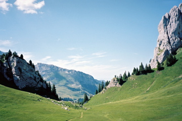
The climb properly stops only at Combette (1829m) with an extra 1.6 km of climbing, the first part being a real killer stretch with constant gradients up to ca. 18-20%. A 200m walk is very much worth the trouble on the track leaving off here to the pass Pertet à Bovets (1839m, asphalt to 1830m), which offer much better views that you will not forget (no problem even with road racing shoes). With this last part I think it should be a 4-5 category climb. I said to myself that this is a pass you would not have wanted to know about considering the last part of the climb.
[CH-VD-1660]