814m - 17.1 km (Lanslevillard)
1832m - 36.9 km (Susa)
1946m - 44.5 km (Susa-Moncenisio)
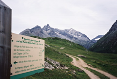
This pass was tarmacced on the north side just as I (thought to have) finished climbing all asphalted passes above 2000 metres in the Alps in 2004! I later went there in 2006 and inspected this pass road. This pass is reached by a road on the French side (north) of the lake near the Col du Mont Cenis/Colle del Moncenisio (2083m). The first stretch of the road to the junction at the other side of the lake is in a very poor state, but is anyway heavily used. From here (1994m) the newly paved road winds its way up some more kilometres to the pass. The last 50 metres are actually gravel. It is irregularly steep, but not very difficult. There are some drainage gullies to remember to go over softly on the return ride. There is only a path down the south side of this pass.
Starting point: to the east in Italy you start in Susa (500m) and climb the normal road up to the border and the lake at the top, go to the other end of the lake and go down by the lake and then straight up on the only asphalted road there until the pass or you could climb up via the village of Moncenisio on a somewhat steep alternative road that eventually joins the main road before reaching the border. From the French side you start already down in Saint-Michel-de-Maurienne (715m) and turn off at Lanslebourg (1399m). If you have climbed over Col de l’Iseran (2764m), you turn off at Lanslevillard (1458m) and join the main road up to Col du Mont Cenis after a little while. Soon after this pass you take off to the right on the asphalted road down to the lake and continue it to the pass.
[FR-73-2183b]