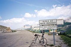
Sign 2087m
1047m - 16.2 km (St. Martin via Le Mounard)
1299m - 28.1 km (Guillaumes)
1550m - 47.5 km (Pont de Gueydan)
851m - 12 km (Colmars)
St. Martin-d’Entraunes (1040m) to the east of the pass is a nice little typical southern french village. Here a somewhat narrow road starts that goes to the pass. After a little while it splits up in two roads and I believe the left (south) one is the nicest and most interesting one. The roads join together again after around 5 km at the steepest place of the climb on this side (around 14%). It is very irregularly steep. The highest point (2096m) is found west of the pass. You can also start already down at the Gorges de Daluis or Guillaumes (788m) if coming from Col du Quartier (Col de Valberg) (1674m), or down before the gorges at Pont de Gueydan (537m).
The road from the west starts just above Colmars (1245m). It used to be the rough side with many difficult drainage gulllies on the descent, but it has newly been resurfaced and only one major drainage gully left.
[FR-04-2093, BIG 310]