772m - 23.1 km (Jausiers)
684m - 15.9 km (Les Gleizolles)
1117m - 30.6 km (Vinádio)
[FR-04-1991]
|
Height | Climbing height - length |
| 1993m | 857m - 32.1 km (Barcelonette) 772m - 23.1 km (Jausiers) 684m - 15.9 km (Les Gleizolles) 1117m - 30.6 km (Vinádio) |
|
| Difficulty | Beauty | |
| 2 (5) | 2-3 (5) | |
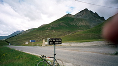
| How to get there | From France in the west you can start in Barcelonette (1136m), Jausiers (1221m) if you come from Col de la Bonette (2715m) or from Les Gleizolles (1309m), if you come from Col de Vars (2109m). It is a very easy climb which is never steeper than around 5%. From Italy to the east you start to climb soon after Vinádio (876m) (from where the road to/from Col de la Lombarde/Colle della Lombarda (2350m) meets the Valle Stura). This is a longer climb and also offers some steeper sections, but on the whole it is relatively easy from this side too. | |
| Other comments | It is mostly beautiful only below Pietrapórzio (1246m) on the Italian side. It is not the nicest pass in the area, but serves as a very useful means of getting to other fine passes in the area. It also makes possible a nice day trip via Col de la Lombarde/Colle della Lombarda (2350m) and Col de la Bonette (2715m). Note that the bicycling on the French side from Les Gleizolles to the pass is officially forbidden due to hazards of rock falls/landslides that they argue would be more difficult for cyclists to escape than motorised vehicles. I am not sure, however, that the authorities enforce this prohobition. [FR-04-1991] |
|
| Map |
||