958m - 11.2 km (Châtelard turn-off)
1928m - 31.3 km (Martigny)
1928m - 28.8 km (Martigny via Le Fays)
1928m - 28.3 km (Martigny via Le Fays shortest)
1871m - 28.3 km (Le Brocard)
1539m - 20.8 km (Martigny via Le Trétien)
1958m - 55.1 km (Chedde-Le Fayet via Châtelard)
1914m - 55.3 km (Chedde-Le Fayet via Finhaut)
274m - 4.9 km (to Lac du Vieux Emosson)
You start the climb where you turn off the Chamonix-Martigny road between Col des Montets (1461m) and Col de la Forclaz (1527m) near the low point of the road (1089m) and then descend a little further (1066m) to cross the L’Eau Noire and then climb on the road that goes either around Finhaut or a little more direct through Finahaut (if you find the fastest way). You could also turn off at the first road after the French border on the Swiss side at Châtelard and climb to Finhaut on a minor road with a +100m descent into Finhaut.
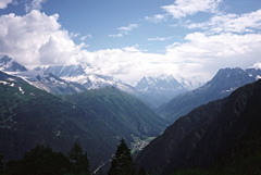
After Finhaut the road is steep, but never goes above something like 13%. It is not very nice until you reach the actual pass and the Lac d’Emosson, where the views of the Mont Blanc mountains are outstanding. This is a dead-end road and you will have to return down to Finhaut. The road on the dam building (1932m) is paved all the way up to the Lac du Vieux Emosson (2206m), but the last part is steep, narrow and has many walkers on a fine day. This last part has been closed for many years (and I was not thinking about going up when I could), but it may be open again in 2016.
The climb is really longer as you would really have started either in Martigny (494m) and climb either the normal road via Col de la Forclaz or up via La Fontaine and Le Fays to La Forclaz. Or you would have started below Chamonix in France at Chedde (589m) and climbed via Vaudagne (1119m), down to Les Houches (991m) and up through Chamonix to Col des Montets (1461m) and then down across the border to the Finhaut road or the Châtelard road to Finhaut.
For completeness sake, there is actually a direct climb to this pass (and I made it on the descent with a road bike). The climb starts just at the entrance to Martigny (if coming from Lac Leman). One climbs up via Salvan and Le Trétien on a nice road, but then there is a curious narrow gravel road up to Finhaut that has some incredibly narrow and steep hairpins after crossing the railway, which is about the only problem with a road bike here, I doubt that this passage could be climbed all the way on a road bike. For mountain bikers only (I believe) there is an even more direct road to climb – an ancient path is going straight (well, in many serpentines) up from Vernayaz to Salvan. The serpentines on this track should be even more difficult to handle (even with a mountain bike I heard that a guy fell on the way up).
[CH-VS-1965]