1280m - 14.96 km - 8.6% (Treffen Klamm)
976m - 10.33 km - 9.5% (Kanzelhöhe fr. Treffen)
1256m - 12.50 km - 10.1% (Gerlitzen fr. Tschöran)
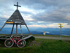
The climb to Gerlitzen top starts from the “back” (north) side at Sauerwald (859m) or at the turn-off for the nice Teuchen landesstrasse at Treffen Klamm (629m). It is a fairly steep climb, but after reaching a ridge (and possibly unnamed pass, Stifterboden) it is easier. The climb has recently been paved all the way to the top. Not much views until the top, but great views from there.
Down in Treffen (537m or 539m) one could climb from the west up a steep road to Gerlitzen, but asphalt runs out earlier here and the highest asphalted point is at Kanzelhöhe (1513m) by an observatory. One could also start the climb to Gerlitzen from the Ossiacher See to the south at the turn-off for Tschöran (513m). This climb (which I have not done) certainly have the best views, but again the road stops before (at 1769m) the top and the track up to the top should be too bad for a road bike. This side is the steepest on average, but the climbs are all fairly similarly steep.
[BIG 650, BIG 649]