870m - 8.83 km - 9.9% (Ponte Mina)
782m - 9.07 km - 8.7% (Sega Digon)
This climb starts in either San Nicolò di Comelico/San Colò (983m) or from Ponte Mina (1031m) where it is a fairly hard climb and especially if you also managed to cycle the last part on the track. If coming down from the Kreuzbergpass/Passo di Monte Croce di Comélico (1636m) then you could conceivably also start already at Sega Digon (1119m) (the road I took down). Nicest would be to take the long high road from Forcella Zovo (1609m) and then go up here from Costa.
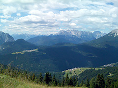
The asphalt (seems broken now to some degree higher up) goes to a rifugio at 1845m and then there is a track that is mostly possible to cycle on with a road bike for 520m to the highest point (you can continue down a few metres to a sign for Monte Zovo 1896m present in 2010 at least at what looks like a pass below the actual mountain). The views are best above the rifugio so it is worth going a bit up here.