1743m - 18.71 km - 9.4% (Tavagnasco)
1762m - 18.82 km - 9.4% (Quassolo)
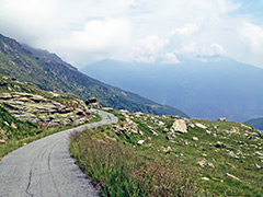
This is quite a climb and a very little known one (still now Strava ‘KOM’ to the top, but some locals have frequented the climbs to Scalaro). It is a very nice climb that starts in Quincinetto (286m) in Piemonte just below the border to Aosta. It has been on the salite.ch site for a long time, but just like the local cyclist I met on teh way down there, they think the climb ends in Scalaro, but this is not at all the way. Even to get to Scalaro it is a pretty hard climb comparable to the climb up to the nearby Colle Pian dei Muli (1443m), but the road continues paved up to 1780m and there are then a few short gravel sections (in 2013) before the last well asphalted stretch to the end where there is nothing (but Alpi Gugliasco & Muande are nearby). The total climb is similar in numbers to Alpe del Gesero (3rd hardest paved road in salite.ch in Switzerland), but maybe more comparable to the easy side of Alpe del Gesero as it is never extremely steep here.
One could possibly start this climb also in Tavagnasco (275m), but according to a somewhat impressive profile for the start of that climb, it has an unpaved section and appareantly asphalt is missing at the high section before the road descends to meet the road from Quincinetto, but it might be wortwhile to explore and if lucky it also may have been paved now. (Descent from ca. 1432m to 1259m.) It looks like one could possible also start the climb in Quassolo. There could be another gravel secttion before joining the Tavagnasco road, but it looks like a quite hard and interesting variant.