Valle Antigorio and later Val Formazza offers a long road north from the junction at Crevoladossola (307m) for the road over the Simplonpass/Passo del Sempione/Col du Simplon (2006m). At the end of Val Formazza the Val Toggia continues to the Passo di San Giacomo (2308m), a pass I have not seeked to explore so far as the surface seems a bit too rough for a road bike these days. It was once suggested to be paved over to Switzerland by Mussolini, but apparently the Swiss declined the offer.
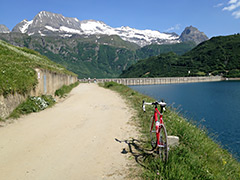
The furthest and highest you can get is to Lago di Morasco (1820m), which is a nice destination (the road can be busy in Summertime). The climb is never really steep, but it is long. There is a slightly steeper section on the old road 2/3rd of the way up with serpentines that the new road now bypasses by a looping tunnel that takes you up to Val Formazza. Cars are not allowed up to the dam, but you can cycle up there and it is quite nice along the dam. The gravel road along the dam in the Valle di Morasco eventually turns to a path up to the Passo del Gries/Griespass (2487m).
[BIG 732]