2031m - 37.3 km (Moûtiers west)
|
Height | Climbing height - length |
| 2370m | 1985m - 34.9 km (Moûtiers) 2031m - 37.3 km (Moûtiers west) |
|
| Difficulty | Beauty | |
| 3-4 (5) | 2-3 (5) | |
| How to get there | This very long climb starts in Moûtiers up the road from Albertville toward Bourg St. Maurice and the famous passes Col de l’Iseran (2764m), Cormet de Roselend (1968m) and Col du Petit St. Bernard (2189m). The classic climb is on the narrow road up to St. Martin-de-Belleville. This D96 road is quite nice and the best part of the climb to famous ski resort Val Thorens. The climb is varyingly steep, but even if not so steep the length will make up for it. The climb up the wider road on the opposite side is a bit longer, but also make you loose more height on the way up and it is therefore similar overall in difficulty. | |
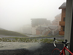
| Other comments | The end of the asphalt road might become longer as they now and then build some more hotels higher up the valley and where the asphalt road now ends is not indicated on any maps, but it is nearby where I indicate on the map below (but to the left of the gravel road I stopped at the same height at. That very last little bit (ca. 100m) of new asphalt was the only really steep part on the whole climb. No views on my visit as it started snowing (July 2014 was a terrible month in the Alps). |
|
| Map |
||