Sign 2231m
1578m - 30.2 km (Le Bourg d’Oisans)
[FR-38-2245a]
|
Height | Climbing height - length |
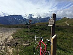
| 2245m (road height 2279m) Sign 2231m |
1254m - 16.6 km (Bge du Chambon/Mizoën) 1578m - 30.2 km (Le Bourg d’Oisans) |
|
| Difficulty | Beauty | |
| 4-5 (5) | 4-5 (5) | |
| How to get there | This is a great climb from Lac du Chambon (1044m) on the main road from Grenoble to Briançon (or from further down at Le Bourg d’Oisans (720m)). After a steep climb to Mizoën (1186m) there is a short descent and climb and then a little descent again at the turn-off from the road up to Col de Sarenne (1999m). Now there is a steepish climb on a smooth road up to Besse which could be a destination of its own, but we continue through the village and follow the small road that continues to be asphalted. This road winds it way rather softly up the mountain, but eventually the asphalt disappears as you come to the end of a valley and climb out of the last trees. The gravel road that continues is mostly rather good though and evenly steep at close to 10% to the top from where a short descent leads to the pass. | |
| Other comments | The views from higher up are among the best in France and surely makes up for the hardships in negotiating the gravel road. There is a small pass sign placed oddly a bit down the other side on a path. I did not try the road that goes down the other side to Mizoën and I believe it will have some rather bad places and likely will mean some walking and as it is quite long I did not dare to try it out. The views ought to be quite good along this road. Mountain bikers usually continues across the Plateau d’Emparis over Col du Souchet (2365m) to Le Chazelet. [FR-38-2245a] |
|
| Map |
||