1398m - 27.9 km (Stalden (Illas))
774m - 7.2 km (Täsch)
|
Height | Climbing height - length |
| 2216m | 1621m - 36.2 km (Visp) 1398m - 27.9 km (Stalden (Illas)) 774m - 7.2 km (Täsch) |
|
| Difficulty | Beauty | |
| 4 (5) | 4-5 (5) | |
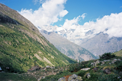
| How to get there | This is a long climb from Visp (652m) with a hard end up from Täsch (1442m) on a narrow nice road. I am showing the alternative road to Stalden from Visp, which I did not take myself, but it looks like a fine alternative to the main road (both are usable). If coming down the steep road from Moosalp (2049m) you start the climb in Stalden (867m) and slightly higher up at the roundabout at Illas (875m) if coming down from the Saastal. This road is the highest asphalted road in Mattertal and along this road you will have great views of the Matterhorn if the weather permit (often clouds linger around the top of Matterhorn). | |
| Other comments | Täsch is were the road up the Mattertal ends for motorised traffic and there are plenty of hotels and parkings here. The highest acessible point with a road bike on gravel roads might be up the Blauherd (2580m), which should offer even greater views of the Matterhorn. Possibly the road is only good up to Sunnegga (2288m) and maybe not even that far. Oddly enough there is little comments on road bicyclists trying to get far up here around, but guess most wish to avoid the busy Zermatt city (that should not be a big problem though). It is very nice at the end in Täschalp and there is a small restaurant here. Water can be found along the road. See also Mattmarksee (2205m). |
|
| Map |
||