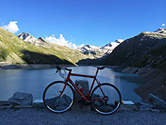
1330m - 24.9 km (Stalden (Illas))
This is a great and classic climb in the area. Other climbs in the Saastal: from Saas-Balen (1483m) one could climb toward Seewjine (Grubengletscher) on a steep road that is asphalted to Heimischgartu (2076m) and continue to at least Hoferälpji (2264m) on a gravel road. This road then continues up in many wide serpentines to two lakes and the glacier above and ends at 2860m, but it is likely too rough to get up on a road bike.
At Talmatten (just before Saas-Grund) (1559m) one could climb up to Tewald (2015m) on asphalt and it should be relatively easy to Triftalp to 2174m, where a gravel road goes to Chrizbode/Kreuzboden (2400m), which might also be possible with a road bike. From Saas-Grund you could climb to Saas-Fee and there might be asphalt up to Honeggu (1901m) above the village. From above Saas-Almagell (1670m) one could climb to Furggstalden (1923m). The hardest of these climbs is likely the one via Saas-Balen toward Seewjine. From Saas-Balen one also has an alternative climb to Unneri Brend (1957m).
[BIG 582]