The following list is intended to give an overview of circa seventy-five challenging European road climbs. The majority of these climbs are completely surfaced but a few unsurfaced ones have been included for comparison. It is not suggested that these (i.e the unsurfaced ones) can be climbed using either a hardcore racing bike or a touring bike. The climbs have been selected somewhat at random. Time did not permit the writing of less cryptic descriptions or the inclusion of more than approximately twenty high-resolution profiles, even these chosen rather haphazardly. It is not claimed that these seventy-five really are Europe’s hardest climbs, instead they are ment to represent something of an overview in case anyone would want to know such useless things. The list will soon be enlarged to around 250 climbs. For each climb one or more of the following sources have been used:
a) Non-commercial profiles produced by single individuals from all over Europe, and
b) Measurements on topographical maps in the scale range 1:10 000-1:50 000
c) A commercial profile, such as the ones produced and sold by Altigraph (France) and Ediciclo (Italy)
[Note: These profiles are copyrighted and have *not* been reproduced here.]
Still, the presence of (hopefully minor) errors cannot be excluded.
The double equal sign == indicates a tarmaced road or section of road, whereas the double tilde ~~ indicates a gravel/dirt surface. The notation [==85%+~~15%] appearing after the length indication for a particular climb means that 85% of it is surfaced/tarmaced/asphalted and 15% is unsurfaced. For the metrically challenged, heights/lengths are also given in feet/miles.
For further information about European road climbs, visit these sites:
Archivio Marzoli (almost 7000 gradient profiles)
Altimetrias.com (Spanish language site)
Le Brevet International du Grimpeur
Claudio Montefusco’s list of challenging climbs. [Web site not found.]
|
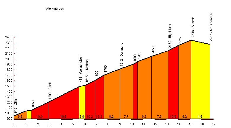
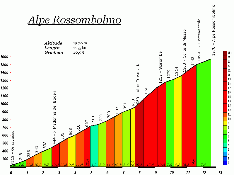
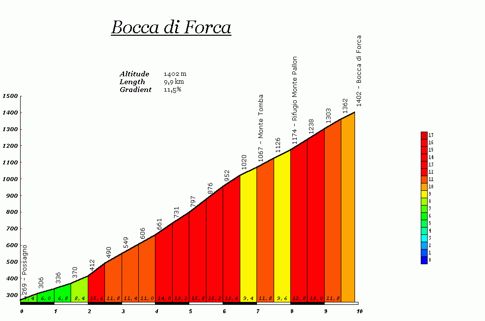
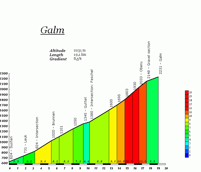
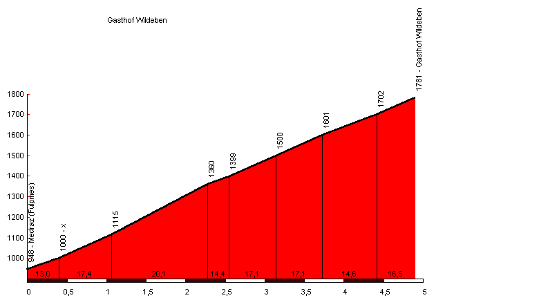
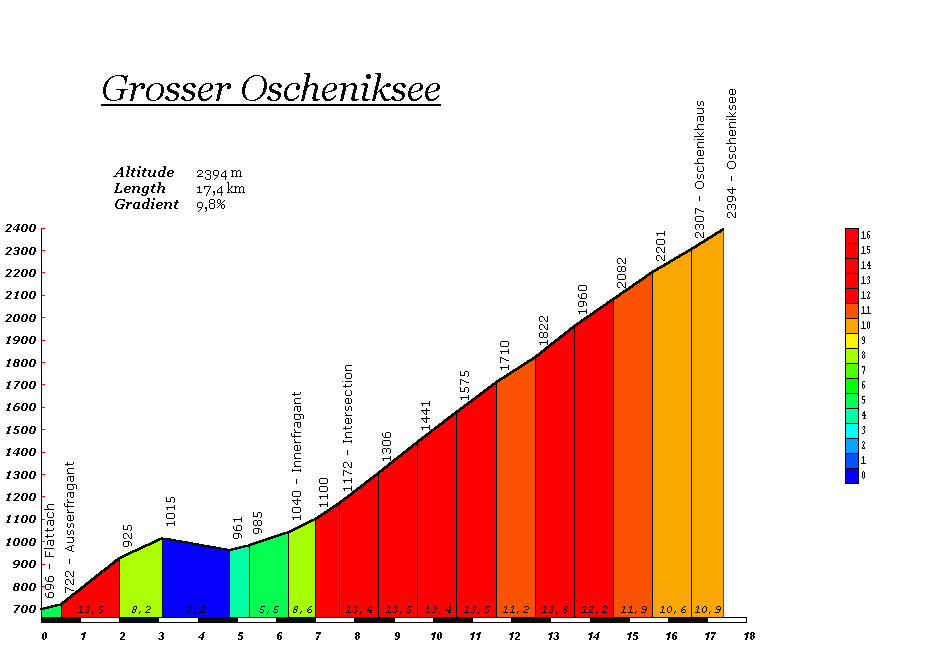
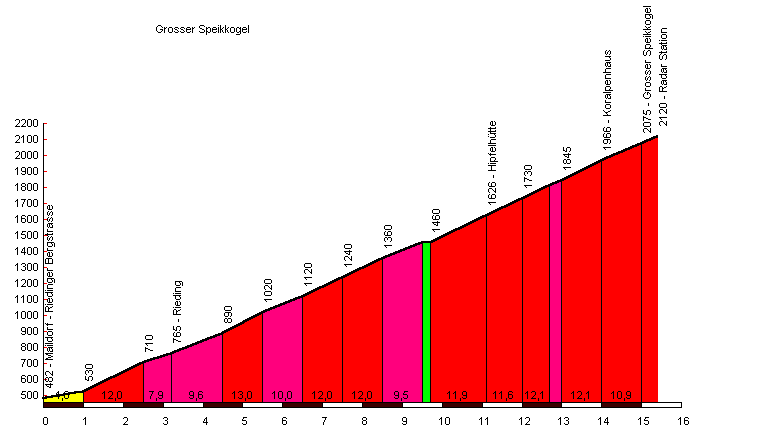
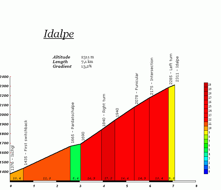
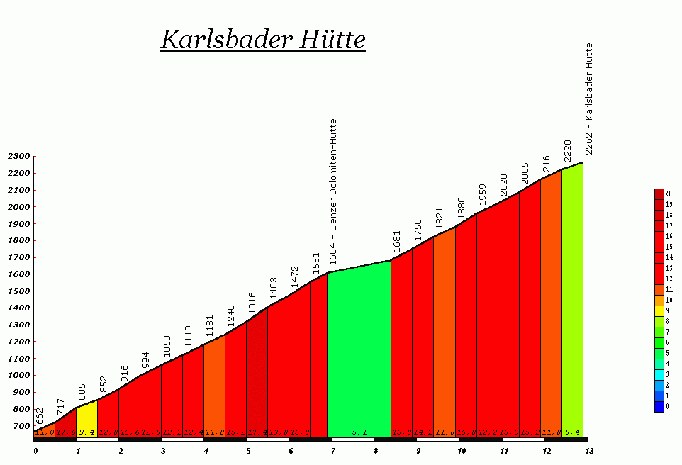
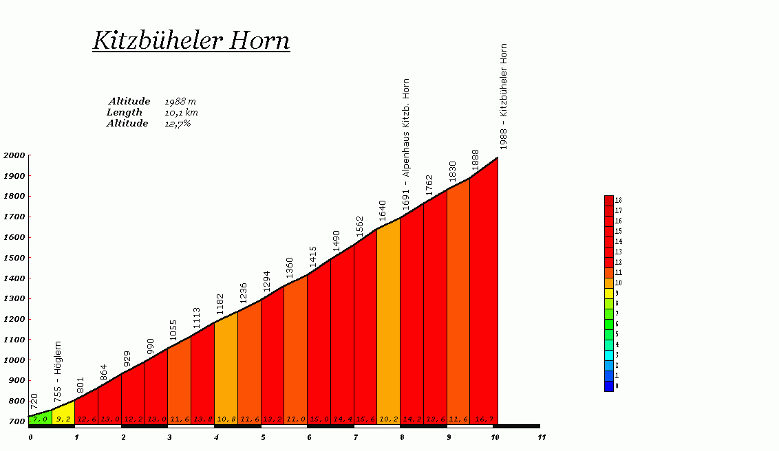
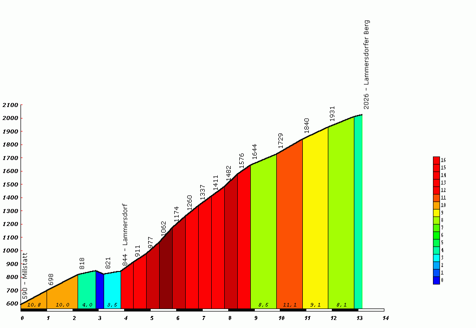
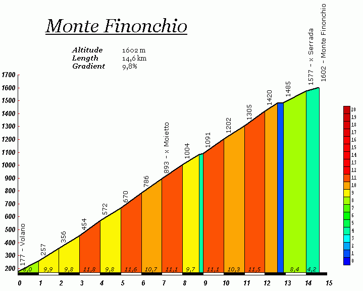
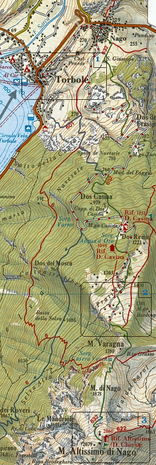
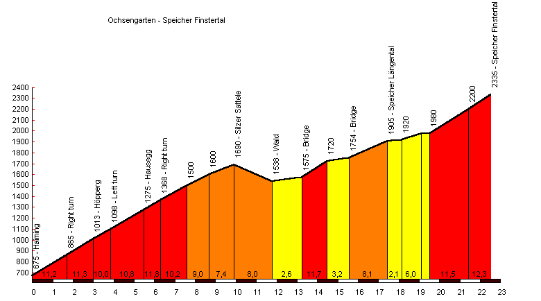
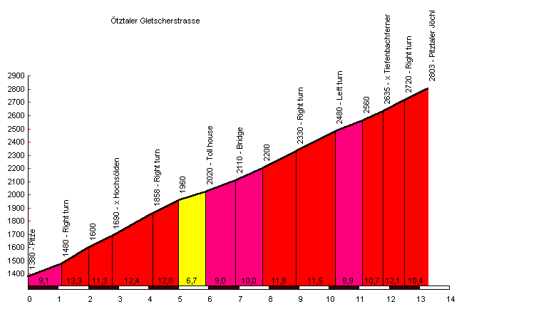
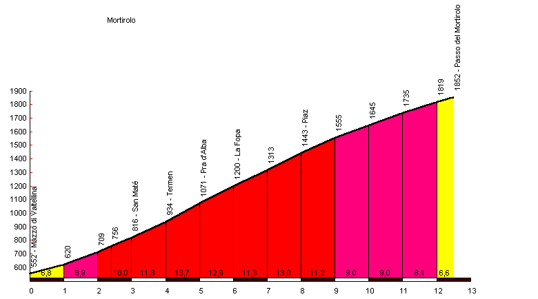
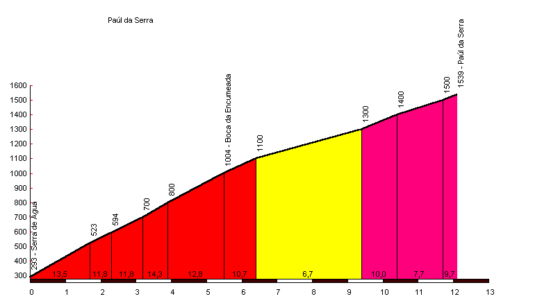
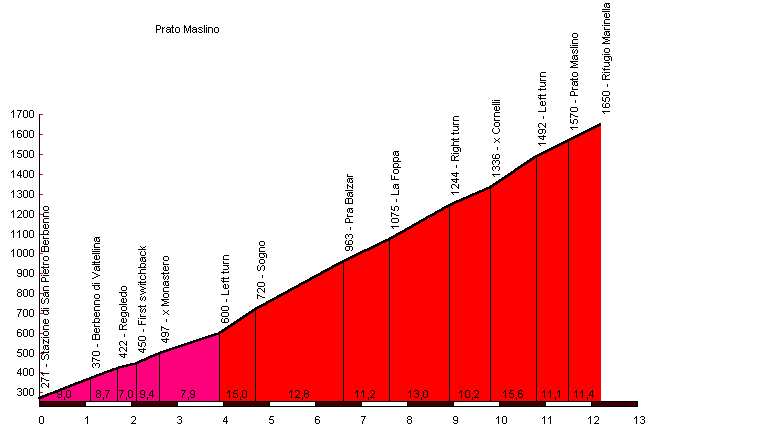
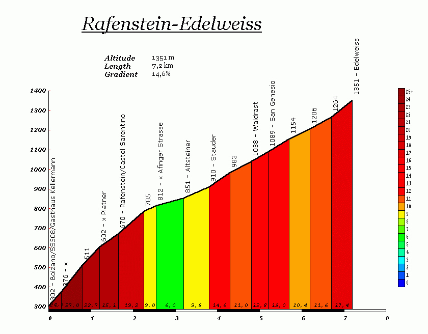
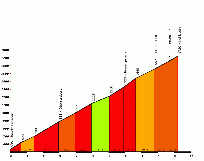
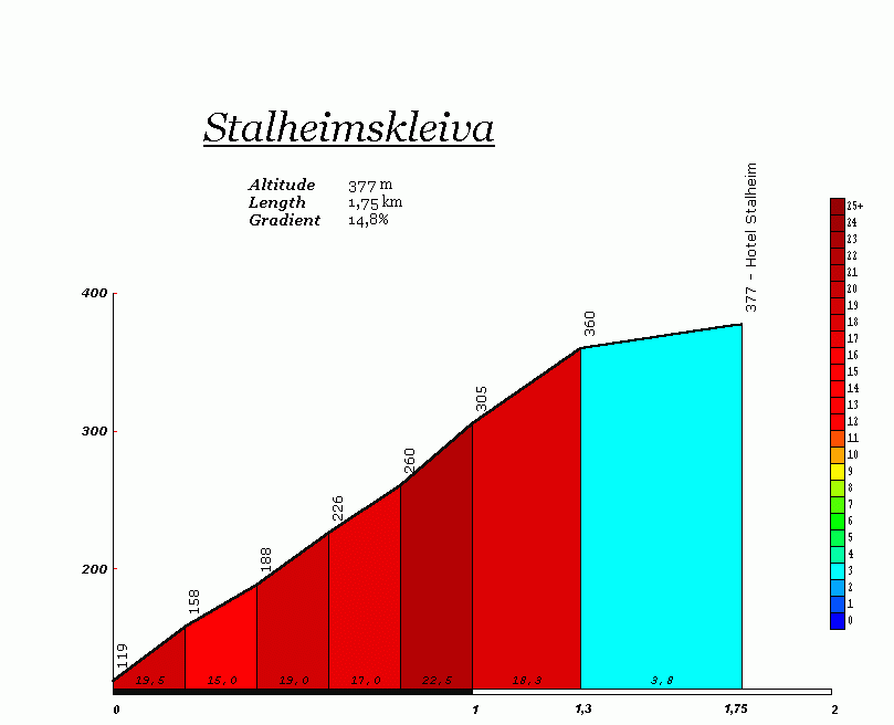
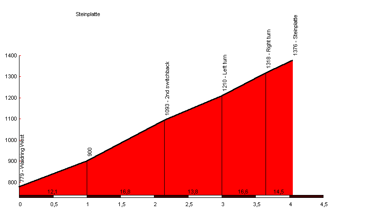
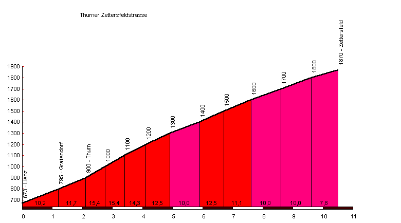
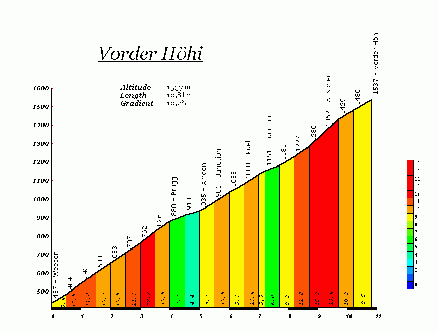
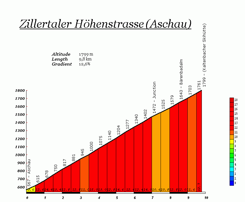
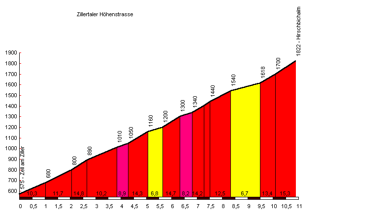
Alp Anarosa (2348 m/7698 ft) from Zillis (Switzerland), length 15,1 km/9,4 mi [==100%], average gradient 9,3%, maximum gradient 15%. The ascent ends 2348 m above sea level, the road itself ends slightly lower, at 2272 m by the Alp Anarosa; completely surfaced climb, the final kilometer of the descent is gravel. About 13,5 km/8,4 mi at 9,7% from Donath to the summit. Located in East Switzerland. Alp Mora (2246 m/7364 ft) from Trin (Switzerland), length 11,4 km/7,1 mi [==15%+~~85%], average gradient 12,1%, maximum gradient 20%. The climb is almost completely gravel and dirt. Close to 1400 m/4590 ft of climbing in 11 km/6,8 mi. Alpe Buri (1525 m/5000 ft) from Settimo Vittone (Italy), length 7,0 km/4,4 mi [==100%], average gradient 13,1%, maximum gradient 20%. Lower Valle d’Aosta, east of Biella. Around seven kilometers of gentle climbing before the foot of the real climb is reached. Alpe di Gesero (1774 m/5816 ft) from Arbedo (Switzerland), length 15,7 km/9,8 mi [==100%], average gradient 9,7%, maximum gradient 18%. Western approach to the summit. The first 13,1 km/8,1 mi to the Alpe della Costa (1600 m/5246 ft) are the steepest, average gradient almost 10,5%. Situated in the Italian-speaking Ticino, close to Bellinzona. Alpe di Gesero (1814 m/5948 ft) from Roveredo (Switzerland), length 15,5 km/9,6 mi [==100%], average gradient 9,8%, maximum gradient 13%. Eastern approach, more regular than the climb from Arbedo. Long, unlit tunnel at the summit. Alpe Mara (1752 m/5744 ft) from Sondrio (Italy), length 12,7 km/7,9 mi [==85%+~~15%], average gradient 11,5%, maximum gradient 18%. Alpe Poverzone (1908 m/6256 ft) from Sondrio (Italy), length 16,0 km/10,0 mi [==60%+~~40%], average gradient 10,1%, maximum gradient 18%. Around fifty kilometers down the valley from the infamous Mortirolo. Part of it (up to Triangia at 800 m/2623 ft) was once climbed in the Tour of Italy. A gravel road for the last seven kilometers approximately. Alpe Rossombolmo (1570 m/5148 ft) from Ornavasso (Italy), length 12,5 km/7,8 mi [==100%], average gradient 10,9%, maximum gradient 32%. Now completely surfaced - with a 300 m long section at 25%. Steeper than the Angliru. Alte Jenesier Strasse-Edelweiss (1351 m/4429 ft) from Bolzano (Italy), length 6,9 km/4,3 mi [==100%], average gradient 15,4%, maximum gradient 30%. Offers an alternative approach to the small mountain hotel ’Edelweiss’ which is only slightly less steep than the approach via the Rafensteiner Bergstrasse. Cars use the new and improved road with normal gradients. The two approaches to the Edelweiss are possibly Italy’s steepest, and are indeed more popular with motorcyclists than pedaling cyclists. Antennamare (1127 m/3695 ft) from Pistunina (Italy), length 9,3 km/5,8 mi [==100%], average gradient 12,2%, maximum gradient 16%. Bèrnia (670 m/2197 ft) from Altea la Vella (Spain), length 5,1 km/3,2 mi [==100%], average gradient 13,0%, maximum gradient 25%. Starts gently with a few sections at 15%. The final 3,1 km/2,0 mi climb 500 m/1640 ft, for an average gradient of 16,2%. A handful of ramps at between 20% and 25%. A miniature-Angliru with pretty bad tarmac. Blockhaus (2045 m/6705 ft) from Lettomanoppello (Italy), length 26,1 km/16,2 mi [==100%], averag gradient 7,4%, maximum gradient 12%. Not as relentlessly steep as the below-mentioned approach from Roccamorice. The elevation gain is almost 2000 m/6600 ft. Blockhaus (2045 m/6705 ft) from Roccamorice (Italy), length 18,5 km/11,5 mi [==100%], average gradient 8,3%, maximum gradient 15%. A famous killer climb in the Giro d’Itala of the seventies. Merckx collapsed here one year during an early stage. The first part of the road climbs 1050 m/3450 ft in in 9,5 km/5,9 mi, for an average gradient of 11,1%. Road slightly modified in recent years, 20% sections removed to make it easier for vehicles to climb it during the winter. Bocca di Forca (1402 m/4597 ft) from Pieve-Cavaso (Italy), length 11,8 km/7,3 mi [==100%], average gradient 10,1%, maximum gradient 20%. Located slightly east of the famous Monte Grappa. Three early kilometers at an average gradient of around 14%. Bocca di Forca (1402 m/4597 ft) from Possagno (Italy), length 9,9 km/6,1 mi [==100%], average gradient 11,4%, maximum gradient 20%. Relatively unknown but considered one of Italy’s hardest climbs. As relentless as the Mortirolo, and the pundits say it is even harder. Camona da Nagiens (2172 m/7121 ft) from Laax-Murschetg (Switzerland), length 10,0 km/6,2 mi [==100%], average gradient 11,0%, maximum gradient 20%. Service road traversing one of Switzerland’s major ski resorts, ends at the Berghaus Nagiens. Close to the Swiss border with Lichteinstein. Cauria [aka Gfrill] (1320 m/4328 ft) from Salorno (Italy), length 11,3 km/7,0 mi [==100%], average gradient 9,7%, maximum gradient 14%. From Salorno - south of Bolzano and located just off the A22/E45 - an asphalted mountain road climbs steeply towards Cauria/Gfrill, along the border of a regional national park (Parco Naturale Monte Corno/Naturpark Trudner Horn). The climb has a relatively flat middle-section of two kilometers in length, the remaining 9,3 km/5,8 mi average 11%. From the end of the asphalted road a minor forest road climbs steeply to a pass (1512 m/4957 ft), crosses the Bolzano-Trento border and then descends towards Gráuno (968 m/3174 ft). From this point on a tarmaced road heads for Cavalese. Cima l’Angliru [aka Picu’l Gamonal] (1571 m/5151 ft) from La Vega (Spain), length 12,5 km/7,8 mi [==100%], average gradient 10,1%, maximum gradient 23,6%. Vuelta a España 1999 and 2000. The final 6,5 km/4,0 mi are the steepest with an average gradient that exceeds 13,5% and a full kilometer at close to 18%. Said to be the hardest climb ever to have been part of a stage in a major professional stage race. (Note on name: Gamonal or Angliru? The sign that appears at the bottom of the climb gives these two names in the regional dialect: Cima l’Angliru/Picu’l Gamonal). Colle di Fauniera [properly: Colle dei Morti] (2480 m/8131 ft) from Pradléves (Italy), length 22,3 km/13,9 mi [==100%], average gradient 7,5%, maximum gradient 16%. A recently surfaced (ca. 1990) climb that was part of the 1999 Giro d’Italia, with devastating effects on the racers. The final 15,5 km/9,6 mi have the same average gradient as the equivalent part of the Mont Ventoux (8,7%) but the Fauniera wins on maximum gradient and elevation. Former military road, just like the Mortirolo and the Monte Zoncolan. Colle San Carlo (1971 m/6462 ft) from Morgex (Italy), length 10,2 km/6,3 mi [==100%], average gradient 10,3%, maximum gradient 16%. Hidden Valle d’Aosta climb; never really steep but unforgiving and sun-exposed. Offers an alternative to part of the main road over the Colle del Piccolo San Bernardo. Cortaccio [aka Monte Brissago] (1067 m/3498 ft) from Brissago (Switzerland), length 6,7 km/4,2 mi [==100%], average gradient 12,8%, maximum gradient 22%. Impossible-to-find Swiss climb (not indicated on most good road maps) located at the Italian border by the Lago Maggiore. The overall numbers are deceptive: The final 4,6 km/ 2,9 mi have in fact an average gradient of 14,5% with several long sections at between 17% and 22%. Faschingalm (1665 m/5459 ft) from Lienz (Austria), length 8,8 km/5,5 mi [==100%], average gradient 11,2%, maximum gradient 15%. Small asphalted mountain road, starts on the eastern outskirts of Lienz, climbs through Grafendorf, Gaimberg, along the east face of the Zettersfeld (2213 m/7256 ft). Seventeen switchbacks. The road to the Faschingalm is one of two tarmaced approaches to the Zettersfeld, the other one being the steep Thurner Zettersfeldstrasse. Feistritzer Alm [aka Oisternig] (1718 m/5633 ft) from Feistritz an der Gail (Austria), length 9,0 km/5,6 mi [==10%+~~90%], average gradient 12,1%, maximum gradient 15%. The road is almost all (good) gravel. The road ends ca. 300 m below the summit of the famous Oisternig peak, at a small mountain hotel. The climb is dead straight with not even one switchback. Feistritzer Alm [aka Oisternig] (1718 m/5633 ft) from Vorderberg (Austria), length 8,8 km/5,5 mi [~~100%], average gradient 13,1%, maximum gradient 15%. The climb has around half a dozen switchbacks; merges with the road from Feistritz around two kilometers below the summit. Fideriser Heuberg (2000 m/6557 ft) from Jenaz (Switzerland), length 12,3 km/7,6 mi [==100%], average gradient 10,2%, maximum gradient 18. A car-restricted, private ski resort road; sections at 18%. Furgge [aka Breithorn] (2451 m/8036 ft) from Grengiols (Switzerland), length 13,6 km/8,5 mi [==22%+~~78%], average gradient 11,6%, maximum gradient 17%. A massive, former military road that is now closed to vehicles. The climb starts in the Rhône river valley (not to far from the Grimselpass); the first three kilometers are tarmaced, the rest is gravel/dirt (regularly maintained). Five kilometers at 15%. Galm (2231 m/7315 ft) from Susten (Switzerland), length 19,1 km/11,9 mi [==92%+~~8%], average gradient 8,5%, maximum gradient 14%. Lower Rhône valley, close to Leuk and Leukerbad. The final 7,0 km/4,4 mi have an average gradient of 11%, sections at 14%. Not yet completely surfaced, the final kilometer and a half is gravel. Gasthof Wildeben (1781 m/5839 ft) from Medraz (Austria), length 4,9 km/3,1 mi [~~100%], average gradient 17,0%, maximum gradient 25%. South of Innsbruck. Because of its steepness it has become legendary among local mountain bikers (but note that this is still a road climb). Steepest kilometer: 20,5%. Gerlitzen-Alpenstrasse (1764 m/5784 ft) from Tschöran (Austria), length 12,0 km/7,5 mi [==100%], average gradient 10,2%, maximum gradient 14%. The longest and steepest of several climbs towards the Gerlitzen peak. Ossiacher See (Carinthia), between Villach and Klagenfurt. Grosser Oscheniksee (2394 m/7849 ft) from Innerfragant (Austria), length 17,4 km/10,8 mi [==100%], average gradient 9,8%, maximum gradient 17%. Immense service road built for the KELAG (Carinthian Hydroelectric Agency). Southeast of the Grossglockner. The overall length and average gradient of this climb are comparable to those of the Mount Washington in the USA. 36 switchbacks in the final 9,5 km/5,9 mi, and an average gradient of more than 13%. Cars are not allowed on the road except during three months of the summer. (Profile: Shows how the continuous climb is preceded by a short steep ramp and a gentle descent). Grosser Speikkogel (2120 m/6951 ft) from Maildorf (Austria), length 15,4 km/9,6 mi [==100%], average gradient 10,8%, maximum gradient 17%. The eastermost of the Carinthian monster climbs. Almost completely unknown to the world. Three kilometers longer than the Mortirolo and with an average gradient that is somewhat higher. In fact, the average gradient is as high as 11,2% for the final 14,4 km/8,9,0 mi - this climb is close to being unparalleled in Europe. Grossglockner-Hochalpenstrasse (2571 m/8430 ft) from Fusch (Austria), length 21,4 km/13,3 mi [==100%], average gradient 8,3%, maximum gradient 14%. Northern approach, including the 1,8 km/1,1 mi side road to the Edelweiss-spitze. The climb is a staple of the Tour of Austria, many professional riders have won here as young amateurs. The final 14,2 km/8,8 mi have an average gradient of 10,1%, relentless but without any truly steep ramps. Steeper than all of Europe’s really high climbs, with the exception of the Ötztaler Gletscherstrasse. Hauser Kaibling (1838 m/6026 ft) from Haus (Austria), length 8,4 km/5,2 mi [==30%+~~70%], average gradient 13,1%, maximum gradient 18%. Minor forest road/service road in one of Europe’s largest ski resorts. Hochsteinstrasse [aka Bannberger Alpe] (2025 m/6639 ft) from Leisach (Austria), length 12,3 km/7,6 mi [==100%], average gradient 10,7%, maximum gradient 18%. East of Lienz (East Tirol). The final 6,2 km/3,9 mi have an average gradient of more than 12%, short sections at 14-18%. The road ends slightly below the 2057 m/6744 ft peak of the Hochstein. Idalpe (2311 m/7577 ft) from Ischgl (Austria), length 7,1 km/4,4 mi [==100%], average gradient 13,2%, maximum gradient 24%. The climb starts in the posh ski town of Ischgl and climbs ever steeply towards the Idalpe; from here there are gravel/dirt roads up to altitudes of close to 3000 m/9800 ft. Surfaced in the last few years. Karlsbader Hütte (2262 m/7416 ft) from Tristach (Austria), length 12,9 km/8,0 mi [==55%+~~45%], average gradient 12,5%, maximum gradient 18%. Southwest of Lienz (East Tirol). Immense is probably the right word to describe this climb, which is half tarmac, half gravel. From Tristach the first 6,9 km/4,3 mi of the road are asphalted and have an average gradient of 13,5%, minimum gradient ca. 10%, maximum gradient 18%. The tarmac gives out at the Lienzer Dolomiten-Hütte, 1604 m/5259 ft. From here a recent service road (all gravel/dirt) leads in six kilometers to the Karlsbader Hütte. Kitzbüheler Horn (1988 m/6518 ft) from Höglern (Austria), length 10,1 km/6,3 mi [==100%], average gradient 12,7%, maximum gradient 22,5%. Raced for the first time in this year’s Tour of Austria (but no higher than the Alpenhaus Kitzbüheler Horn at 1670 m/5475 ft) and many of the racers claimed it was one of the hardest climbs they had ever done. The final 2,2 km/1,4 mi are on a privately owned and car-restricted road owned by the ÖRF (the National Austrian Broadcasting Company), width of road bed approximately one meter, maximum gradient 22,5%. The climb ends just a few meters below the 1996 m/6544 ft) peak of the Kitzbüheler Horn, at the foot of massive TV towers and with a final narrow, steep section at 19%. La Riposa (2205 m/7230 ft) from Susa (Italy), length 21,1 km/13,1 mi [==75%+~~25%], average gradient 8,1%, maximum gradient 15%. Susa-valley, approximately 50 km/30 mi east of Torino. The not yet completely surfaced road climbs along the south face of the unmistakeable Monte Rocciamelone (3538 m/11600 ft). Lammersdorfer Berg (2026 m/66242 ft) from Lammersdorf (Austria), length 13,1 km/8,1 mi [==100%], average gradient 11,0%, maximum gradient 23%. The overall numbers for the climb are deceptive. In fact, the first 5,3 km/3,3 mi are particularly steep, an average gradient of 15,2% with long sections at more than 20%. This climb, which is not indicated in most road maps, is situated in Carinthia, on the north shore of the Millstätter See. Las Nieves (1900 m/6230 ft) from Carizal (Spain), length 26,7 km/16,6 mi [==100%], average gradient 6,9%, maximum gradient 23%. A climb that in overall length and altitude difference is equal to the Stelvio in the Italian Alps. Situated on the Gran Canaria island. Extremely steep between kilometers 11 and 14, average 13%, several long sections at 17-23%. Malga Palazzo (1560 m/5115 ft) from Besenello (Italy), length 6,6 km/4,1 mi [==100%], average gradient 20,5%, maximum gradient 30%. Incredible though it may sound, this climb which is completely surfaced (tarmac and concrete), actually exists. Malga Table (1616 m/5298 ft) from Pieve di Bono (Italy), length 10,7 km/6,6 mi [==100%], average gradient 10,3%, maximum gradient 18%. Valle del Chiese, south of the Adamello/Gruppo di Brenta and east of the Garda Lake. Surfaced and, indeed, clearly marked on most good road maps, but still almost completely unknown. (See also: Rifugio Alpo). The first six kilometers are the steepest, average gradient ca. 11%. Mölltaler Gletscherstrasse (2365 m/7754 ft) from Ausserfragant (Austria), length 21,9 km/13,6 mi [==100%], average gradient 10,2%, maximum gradient 16%. Service road built for the construction of a storage dam; southeast of the Grossglockner. The average gradient refers to those sections of the road that are climbing, for there are three intermediate descents that effectively break it into three climbs. Note however, that when the road climbs, it does so really steeply. Summing the sections that have an average gradient of 10% or more, one finds that the Mölltaler Gletscherstrasse (which is now closed to cars) consists of around 11 km/7 mi of steep ramps at an average gradient of more than 12%. The minor side road that appears after 1/4 of the climb gives access to the Grosser Oscheniksee and is an even steeper. Mont Ventoux (1909 m/6259 ft) from Bedoin (France), length 21,5 km/13,4 mi [==100%], average gradient 7,5%, maximum gradient 12%. No introduction needed. Note, however, that the final 15,2 km/9,5 mi are a bit steeper than the rest, average gradient 8,7%. First raced in the 1949 edition of the Dauphiné Libéré, in the Tour de France from 1951. Monte Altissimo di Nago (Rifugio Damiano Chiesa) (2053 m/6731 ft) from Ávio (Italy), length 26,5 km/16,5 mi [==85%+~~15%], average gradient 7,2%, maximum gradient 15%. Monte Camoscio (890 m/2918 ft) from Gravellona Toce (Italy), length 4,0 km/2,7 mi [==100%], average gradient 16,3%, maximum gradient 30%. Located across the valley from the equally steep but longer climb to the Alpe Cortevecchio. Overlooks parts of the Lago Maggiore, to the south the Mottarone with its well-known climb. (Profile by Livio Marzoli) Monte Crostis (1934 m/6341 ft) from Comeglians (Italy), length 15,5 km/9,6 mi [==100%], average gradient 9,0%, maximum gradient 18%. A very gentle start to this climb; the final 14,0 km/8,7 mi do in fact have an average gradient of 10,0%. Nearby is the horrifically steep climb of the Monte Zoncolan, with which it can be paired (but not compared). Monte Finonchio (1602 m/5252 ft) from Volano (Italy), length 14,6/9,1 mi [==70%+~~30%], average gradient 9,8%, maximum gradient 13%. Monte Grappa (1735 m/5689 ft) from Semonzo (Italy), length 19,8 km/12,3 mi [==100%], average gradient 7,9%, maximum gradient 15%. Monte Padrio [aka Valico di Baite Salena] (1798 m/5895 ft) from Lombro (Italy), length 9,3 km/5,8 mi [==100%], average gradient 9,6%, maximum gradient 25%. The south side of the Mortirolo, giving an alternative access to this famous pass. Very irregular climb, long sections at 12-15%, one short section at 25%. The climb of the Monte Padrio could in fact be proposed as a stage finishing climb of a Giro stage that were to climb the Mortirolo. The distance from the foot of the Mortirolo-descent to the start of this climb is less than 10 kilometers. Monte Poverello (1260 m/4131 ft) from Guidomandri (Italy), length 11,7 km/7,3 mi [==100%], average gradient 10,8%, maximum gradient 20%. Monte Varagna [aka Prati di Nago] (1529 m/5013 ft) from Torbole (Italy), length 15,1 km/9,4 mi [==100%], average gradient 9,7%, maximum gradient 17%. At the Garda Lake’s northeastern end. Nearby is the even steeper Punta Veleno (see below). A map. Monte Zoncolan (1730 m/5672 ft) from Ovaro (Italy), length 10,2 km/6,4 mi [==100%], average gradient 11,8%, maximum gradient 21%. Impressively steep: A section of exactly 6,0 km/3,7 mi has an average gradient of 15%, steepest kilometer 19,5%. Three short, unlit, unsurfaced tunnels close to the summit. This is a pass road. Ochsengarten-Speicher Finstertal (2335 m/7656 ft) from Haiming (Austria), length 22,5 km/14,0 mi, average gradient 8,8% (excluding intermediate descent) [==100%], maximum gradient 16%. Starting point Haiming, located between Imst and Innsbruck in the Inn valley. The climb has a total elevation gain of 1812 m/5941 ft. The first 9,9 km/6,1 mi to the Silzer Sattele (1690 m/5541 ft) are steep, average gradient 10,3%. After this climb the road descends for a few kilometers, to Wald (1538 m/5043 ft). The next 7,7 km/4,8 mi are easier, with the exception of a section of more than a kilometer at 12%, maxima at 16%. Finally, shortly before reaching the Kühtai-Sattel (2017 m/6613 ft), leave the main road and follow the steep asphalted service road to the Finstertal storage dam (could be closed to cyclists, circular tunnel close to the summit). Ötztaler Gletscherstrasse (2803 m/9190 ft) from Pitze (Austria), length 13,3 km/8,3 mi [==100%], average gradient 10,7%, maximum gradient 18%. The highest of all surfaced Alpine climbs, one meter higher than France’s La Bonette. It is also substantially steeper than all of Europe’s truly high climbs. The road gives access to a summer skiing area high above Sölden, a posh ski resort town. Palfries (1711 m/5610 ft) from Azmoos (Switzerland), length 12,0 km/7,5 mi [==100%], average gradient 10,1%, maximum gradient 18%. Very twisty and curvy road close to the Switzerland-Lichenstein border. Passo Fittanze della Sega (1399 m/4587) from Sdruzzinà (Italy), length 14,1 km/8,8 mi [==100%], average gradient 8,8%, maximum gradient 18%. Traverses the Monti Lessini east of the Garda Lake. Quite recently surfaced and improved - formerly it had sections of 26% gradient. The first 10,0 km/6,2 mi are the steepest, with an average gradient of exactly 10%. Steepest kilometer: 14%. Passo del Mortirolo (1852 m/6072 ft) from Mazzo di Valtellina (Italy), length 12,5 km/7,8 mi [==100%], average gradient 10,4%, maximum gradient 20%. The famous Giro d’Italy climb. Not quite Europe’s hardest or steepest but right up there among them. Raced in the Tour of Italy 1991, 1994, 1996, 1997 and 1999. The Mortirolo is located in the Alpi Orobie (Orobian Alps), not in the Dolomites. Passo di Nigra [aka Nigerjoch] (1688 m/5534 ft) from Blumau (Italy), length 18,0 km/11,2 mi [==100%], average gradient 7,6%, maximum gradient 24%. East of Bolzano, Dolomites. Apart from the 1370 m/4500 ft elevation gain, it is really hard only because of a very steep two-kilometer section below the old village of Tires, average gradient ca. 17%, maximum gradient 24%. Passo dello Stelvio (2758 m/9043 ft) from Prato allo Stelvio (Italy), length 24,5 km/15,2 mi [==100%], average gradient 7,6%, maximum gradient 15%. Located in the Alpi Retiche (Rhetian Alps), not in the Dolomites. First raced in the 1953 Giro d’Italy, and often left off this race because of its high altitude and the risk of avalanches and blizzards. The second highest surfaced through-road of the Alps. Never really steep but with a substantial elevation gain: 1860 m/6100 ft. Paúl da Serra (1225 m/4016 ft) from Calheta (Madeira), length 9,2 km/5,7 mi [==100%], average gradient 13,3%, maximum gradient 20%. One of several narrow and incredibly steep tarmaced lances on the steep but accessible south side of Madeira, a few kilometers west of the capital Funchal. Not more than a handful of switchbacks. Paúl da Serra (1403 m/4600 ft) from Canhas (Madeira), length 9,3 km/5,8 mi [==100%], average gradient 14,0%, maximum gradient 20%. Ca. fifteen switchbacks to the top. The road climbs from just above sea level and into the swampy high altitude plain of the Paúl da Serra. This approach is neither a major nor a secondary road, instead it’s a narrow tarmaced lane that is primarily used by farmers. Paúl da Serra (1560 m/5115 ft) from São Vicente (Madeira), length 17,6 km/10,9 mi, average gradient 8,9%, maximum gradient 17%. Paúl da Serra (1539 m/5046) from Serra de Água (Madeira), length 12,1 km/7,5 mi [==100%], average gradient 10,3%, maximum gradient 18%. Part of a major road connection between Ribeira Brava on Madeira’s south coast and São Vicente on the north coast; crosses the Bocca da Encumeada (1004 m/3292 ft), at this point a left turn towards the high altitude Pául da Serra plain. The first 6,4 km/4,0 mi are the steepest, average gradient 12,6%. Peter-Anich-Hütte (1909 m/6259 ft) from Rietz (Austria), length 9,1 km/5,7 mi [==100%], average gradient 14,1%, maximum gradient 30%. A private, car-restricted service road west of Innsbruck. Climbs gently for the first six kilometers, whereas the rest of the climb sports an average gradient of almost 20% (for approx. three kilometers) with sections that are as steep as 30%. [This must have been confused with the nearby road to Wasserschloss-TIWAG (1918m) that is asphalted contrary to the Anich-Hütte road.] Pic du Midi de Bigorre [aka Col des Laquets] (2637 m/8646 ft) from Luz-St-Sauveur (France), length 24,7 km/15,35 mi [==77%+~~23%], average gradient 7,8%, maximum gradient 13%. Latest note: As of October 2002 the 5,7 km long section between the Col du Tourmalet and the Col des Laquets has still not been tarmacked. As part of the restoration of the observatory and other structures at and below the summit of the Pic du Midi, the 5,5 km/3,4 mi long side road from the Col du Tourmalet to the Col des Laquets has now been paved [Note: It should have been paved last year but this was not done; instead it is now said to have been surfaced early this summer]. With the additon of this side road, both approaches via the Tourmalet gain in stature and are now comparable to other of Europe’s top-level climbs, like the Grossglockner, Blockhaus and Roque de los Muchachos, both in elevation gain and average gradient. Pic du Midi de Bigorre [aka Col des Laquets] (2637 m/8646 ft) from Sainte-Marie-de-Campan (France), length 22,9 km/14,2 mi [==77%+~~23%], average gradient 7,8%, maximum gradient 13%. The first 17,2 km/10,7 mi are identical with the classic eastern approach to the Col du Tourmalet, the final 5,7 km are still (10/2002) all gravel Pico do Areeiro via Carreiras de Baixo (1814 m/5948 ft) from Funchal (Madeira), length 17,8 km/11,1 mi [==100%], average gradient 10,2%, maximum gradient 25%. Very steep climb starting on the eastern outskirts of Madeira’s capital Funchal. Part of the climb follows a major south-north connection, part of it the steep and once cobbled city streets of Funchal. The steep section ends around the 1000 m/3300 ft mark, the rest is a gentle climb (except for a short, very steep section towards the summit). Madeira’s highest road. Pico do Areeiro via Monte (1814 m/5948 ft) from Funchal (Madeira), length 18,9 km/11,7 mi [==100%], average gradient 9,6%, maximum gradient 25%. Alternative approach to the Pico do Areeiro: Starts in Funchal but doesn’t follow the major road, instead it uses part of the famous, once cobbled but now tarmaced basket sled streets. The climb from sea level to the Poiso pass at 1410 m/4623 ft measures 12,2 km7,6 mi and has an average gradient of 11,6%; the main road is three kilometers longer. The final section Poiso-Pico do Areeiro (6,7 km/4,2 mi) is gentle, with the exception of the very last ramp at 19%. Pico Veleta (3365 m/11033 ft) from Pinos Genil (Spain), length 42,6 km/26,5 mi [==100%], average gradient 6,1%, maximum gradient 13%. Europe’s highest altitude climb (both among tarmaced and unsurfaced roads), with an elevation gain that is also a European record: 2600 m/8500 ft. Never really steep. The first 25 km/15,5 mi takes the cyclist up to an altitude of around 2500 m/8200 ft, and it is this part that is frequently raced in the Vuelta a España. Very rough surface in the final kilometers (but this could vary from year to year). Pra Campo (1764 m/5784 ft) from Tirano (Italy), length 12,9 km/8,0 mi [==60%+~~40%], average gradient 10,2%, maximum gradient 16%. Less than ten kilometers south of the Mortirolo, climbing the steeply rising north face of the Valtellina. Not yet completely surfaced. Prato Maslino (1650 m/5410 ft) from Berbenno di Valtellina (Italy), length 12,2 km/7,6 mi [==100%], average gradient 11,4%, maximum gradient 20%. Located in the same valley as the Mortirolo (the Valtellina), east of the Como Lake, but is said to be much, much harder. This dead-end climb could be used as part of a Giro d’Italia stage together with one or more of the following famous climbs: Mortirolo, Gavia, Stelvio. Punta Veleno [aka Passo del Telégrafo] (1111 m/3643 ft) from Porto di Brenzone (Italy), length 7,2 km/4,5 mi [==100%], average gradient 14,4%, maximum gradient 20%. Located at the eastern shore of the Garda Lake, not too far from Verona. Another Italian killer climb that easily beats the Mortirolo when it comes to steepness, if not fame. Climbs 639 m/2095 ft over a length of just 4,0 km/2,5 mi, for an average gradient of 16,0% (á la the Monte Zoncolan). A recently surfaced, former military road, as are the Zoncolan and the Mortirolo. Rafenstein-Edelweiss (1351 m/4429 ft) from Bolzano (Italy), length 7,2 km/4,5 mi [==100%], average gradient 14,6%, maximum gradient 33%. The first concrete-surfaced part, the Rafensteiner Bergstrasse, measures 2,5 km/1,6 mi and has an average gradient of more than 20%. With maxima at 33% this is the steepest sealed and unrestricted Alpine road. Despite the relative brevity, the road climbs as much as 1050 m/3450 ft. Reinsfjellet (994 m/3259 ft) from Torvika (Norway), length 5,5 km/3,4 mi [~~100%], average gradient 16,4%, maximum gradient 25%. The road climbs a lone, isolated peak where mountain meets sea. A service road for use by the National Telecommunications company, unsurfaced and closed to vehicles. At the summit splendid views over the rugged coast of the Atlantic. Rifugio Alpo (1480 m/4852 ft) from Baitoni (Italy), length 10,2 km/6,35 mi [==100%], average gradient 10,9, maximum gradient 20%. Lone, isolated climb east in Trentino’s Valle del Chiese, west of the Garda Lake. Still, completely tarmacced. The final 6,6 km/4,1 mi are steep, average gradient 12,6%. Rifugio Bárbara-Colle del Baracun (2406 m/7889 ft) from Bóbbio Péllice (Italy), length 14,5 km/9,0 mi [==62%+~~38%], average gradient 11,7%,maximum gradient 20%. One of the few truly steep paved climbs in the western part of the Alps (Piedmont). The first 9,0 km/5,6 mi are paved, average gradient 11,3% but with a 6,6 km/4,1 mi subsection at an average gradient of almost 13%. From just below the Rifugio Bárbara an old and unsurfaced military road climbs in a little less than six kilometers to the Colle del Baracun (2373 m/7780 ft) which is at a slightly lower elevation than the high point of the road. (Profile: Shows surfaced part of climb). Rifugio Marinelli [aka Forcella Morareto] from Tors (Italy), length 12,7 km/7,9 mi [==55%+~~45%], average gradient 10,4%, maximum gradient 17%. A former military road, just like the nearby Monte Zoncolan. The steep part has a dirt surface, 5,7 km/3,6 mi, average gradient 13,4%. Rionda (2156 m/7069 ft) from Lavey-les-Bains (Switzerland), lenght 17,9 km/11,1 mi [==45%+~~55%], average gradient 9,7%, maximum gradient 18%. Another one in a long series of steep military roads in the Alps, only this time it is still in use and partly closed to all forms of traffic. Sixty switchbacks in all. The tarmac gives out after ca. eight kilometers, in Morcles (1160 m/3803 ft), the rest is a well-maintained gravel road; final 5-6 km/3-4 mi usually closed to all forms of traffic, including bicycles. Roque de los Muchachos (2400 m/7869 ft) from Garafía (Spain), length 28,2 km/17,5 mi [==100%], average gradient 7,3%, maximum gradient 12%. Immense climb on the island of La Palma. An elevation gain of 2061 m/6757 ft means it beats such mainland giants as the Stelvio and the Grossglockner. Never really steep. Roque de los Muchachos (2400 m/7869 ft) from Santa Cruz de la Palma (Spain), length 41,7 km/25,9 mi [==100%], average gradient 5,8%, maximum gradient 12%. Immense climb on the island of La Palma. The total elevation gain is close to 2400 m, or approximately 8000 feet. Roque de los Muchachos (2400 m/7869 ft) from El Tablado (Spain), length 32,2 km/20,0 mi [==100%], average gradient 8,6% (excluding intermediate descent). The climb starts in the small village of El Tablado, located 285 meter above sea level on La Palma’s rugged northwestern coast. The road climbs steeply for the first 7,0 km, average gradient 11,5%. This is followed by gentle climbing and descending for the next 6,1 km, until the village Llano Negro (937 m). Here the road starts climbing continuously again, all the way up to the the astronomical observatories situated atop the Roque de los Muchachos (2400 m). The total elevation gain is 2300 m/7500 ft. Rossfeld-Kehlsteinstrasse (1700 m/5639 ft) from Berchtesgaden (Germany), length 10,5 km/6,5 mi [==100%], average gradient 11,1%, maximum gradient 24%. Quite possibly Germany’s steepest climb. Unfortunately, all but the first three kilometers of it are also closed to all forms of traffic, with the exception of special buses. Nevertheless, it has been and can be ridden on a bike, if you are willing to be accompanied by a police car and can afford to pay the fine. It is in fact none other than the access road to Nazi-Germany’s infamous ’Eagle’s Nest’. Salzbergstrasse (1482 m/4859 ft) from Absam (Austria), length 6,4 km/4,0 mi [==78%+~~22%], average gradient 13,5%, maximum gradient 32%. The Salzbergstrasse has fallen into oblivion and is no longer regularly maintained, with the result that the final kilometer and a half (with its 32% section) no longer has a hard surface. However, tarmaced ramps at 25-27% are still intact. Close to Innsbruck. Stalheimskleiva (377 m/1236 ft) from Sivlesøyni (Norway), length 1,75 km/1,1 mi, average gradient 14,8%, maximum gradient 22,5%. The short climb to the Stalheim hotel is Norway’s steepest: It gains 240 m in the first 1,3 km, for an average gradient of almost 19%. One switchback every onehundred meters on average. Steinplatte (1376 m/4511 ft) from Waidring (Austria), length 4,1 km/2,6 mi [==100%], average gradient 14,6%, maximum gradient 24%. From Waidring, northeast of St.Johann in Tirol and just inside the Austro-German border, a very narrow but asphalted mountain rode climbs in just six switchbacks to the Gasthof Steinplatte under the Bernfarchtkogel (1537 m/5039 ft). In true Tyrolean fashion the road has gradients that almost always exceed 12-13%. Thurner Zettersfeldstrasse (1870 m/6131 ft) from Lienz (Austria), length 10,5 km/6,5 mi [==100%] average gradient 11,4%, maximum gradient 16%. The climb starts on the outskirts of Lienz, the major town in East Tirol. Never drammatically steep but gradients rarely go below 8-9% for any longer section. Vorder Höhi (1537 m/5039 ft) from Weesen (Switzerland), length 10,8 km/6,7 mi, average gradient 10,3%, maximum gradient 18%. Zillertaler Höhenstrasse (1799 m/5898 ft) from Aschau (Austria), length 9,8 km/6,1 mi [==100%], average gradient 12,6%, maximum gradient 18%. Tirol’s Zillertaler Höhenstrasse consists of no less than five climbs, all of which are about the same length and average gradient as the Tour of Italy’s famed Mortirolo pass. The Aschau approach has a section of six kilometers/four miles at an average gradient of almost 14%. Zillertaler Höhenstrasse (2015 m/6607 ft) from Hippach (Austria), length 14,1 km/8,8 mi [==100%], average gradient 10,2%, maximum gradient 17%. The southermost and less steep of all the five approaches. Nevertheless, it compares favourably with the Mortirolo when it comes to length and average gradient. This is the only one of the five climbs to reach the highest point along the road. Zillertaler Höhenstrasse (1760 m/5770 ft) from Kaltenbach (Austria), length 10,2 km/6,3 mi [==100%], average gradient 11,6%, maximum gradient 20%. Relentlessly steep all the way through. It has the final 2,5 km/1,6 mi in common with the climb starting in Ried; one long ramp at 18-19%. Steepest kilometer: 15,8%. Zillertaler Höhenstrasse (1760 m/5770 ft) from Ried (Austria), length 10,6 km/6,6 mi [==100%], average gradient 11,4%, maximum gradient 20%. The northernmost of the five ramps giving access to the Zillertaller Höhenstrasse; particularly steep in the final two kilometers, with long sections at 18-19%; old, worn-down tarmac and a narrow road bed. After a short descent to the Kaltenbacher Skihütte (1460 m/4787 ft) the road continues climbing to the summit at 2015 m/6607 ft, with flatter sections in between ramps that are as steep as 20%. Zillertaler Höhenstrasse (1822 m/5974 ft) from Zell am Ziller (Austria), length 10,9 km/6,8 mi [==100%], average gradient 11,5%, maximum gradient 20%. This approach is usually not marked on road maps; still it is completely surfaced. Steepest kilometer: 14%. 200-300 m ramps at 16-18%. The steep climb ends at the Hirschbichlalm; from here the road rises gently for four kilometers to the summit below the Arbiskopfjoch (2015 m/6607 ft). Zirknitztal-Grossee (2417 m/7925 ft) from Döllach (Austria), length 15,2 km/9,5 mi [==100%], average gradient 9,2%, maximum gradient 15%. Final 4,0 km/2,5 mi average approximately 12%. Situated south of the Grossglockner-massif; one of a series of substantial and extremely steep climbs in this part of Austria (Carinthia), all built as part of the development of storage dams and hydroelectrical power plants (Mölltaler Gletscherstrasse, Grosser Oscheniksee). The road is closed to vehicles for the final 50% of its length. |
![Cima l’Angliru [aka Picu’l Gamonal] (1571 m/5151 ft) from La Vega (Spain)](images/angliru.gif)
![Cortaccio [aka Monte Brissago] (1067 m/3498 ft) from Brissago (Switzerland)](images/cortaccio.gif)
![Hochsteinstrasse [aka Bannberger Alpe] (2025 m/6639 ft) from Leisach (Austria)](images/hochsteinhutte.gif)
![Monte Varagna [aka Prati di Nago] (1529 m/5013 ft) from Torbole (Italy)](images/montevaragna.gif)
![Pic du Midi de Bigorre [aka Col des Laquets] (2637 m/8646 ft) from Luz-St-Sauveur (France)](images/picmidiluz.gif)
![Punta Veleno [aka Passo del Telégrafo] (1111 m/3643 ft) from Porto di Brenzone (Italy)](images/puntaveleno.gif)