I was up normal time and did not quite notice that I had a fractured rib. – I did not have any real problems cycling the remaining days while sitting down and not going at full speed. It was yet again a lovely morning and I was a bit more curious than usual about the ride for today as there was rather many uncertainties that I could not get information about beforehand. I had heard that the road up above Verbier to Croix de Coeur should not be difficult even if it was unpaved (Fred Wright told me). I soon reached the road climbing up to Verbier.
The gradients up to Verbier (1490 m) are steady but reasonable at around 8-9% and the road is nice even if rather busy with local traffic. Verbier is really like a big town and it seemed to be ever-expanding with new houses being built at several places. It was not totally clear which way to go through Verbier up to the col as there is perhaps only one extremely small sign mentioning it in the town. But if you continue the serpentine as it went up to the town and continue like that, you will probably be on the right road.
Above the town you get rid of most traffic, but get a smaller road instead. When you eventually reach a small section that goes through wood the road deteriorates somewhat and gets rather steep at places (probably it is above 10% on average to the top from there). After some time more the road is unpaved to the top with plenty of wooden drainage gullies across the road that occasionally requires a little care in passing over.
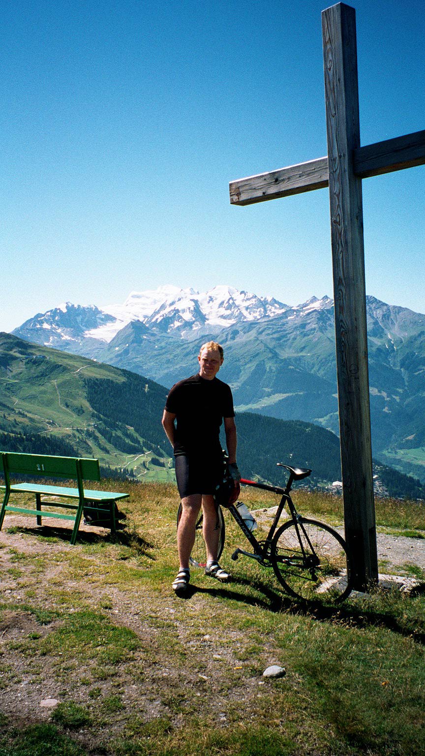
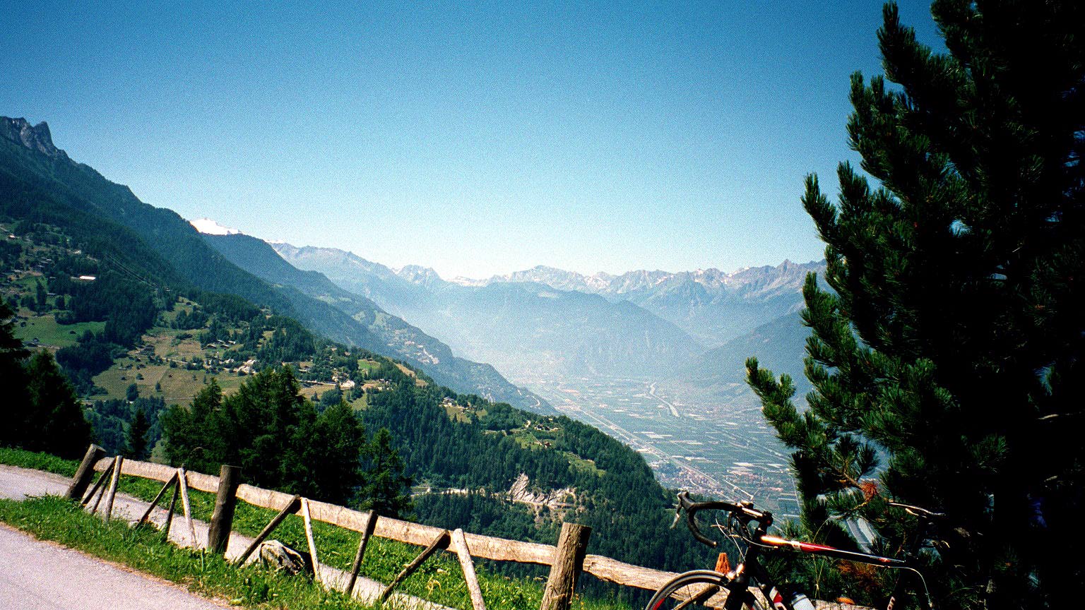
The photo at Croix de Coeur (2174 m) above was taken by some older people from Geneva, who enjoyed to go there every now and then with a car (apparently it was their favourite pass in the area). It was indeed a very sweet pass and quite rewarding – I recommend it strongly! (The mountain seen is probably Combin de Corbassière (3715 m).)
The Michelin maps of Swiss are very accurate on this side up to Croix de Coeur, but on the other side and of the roads up in the Valais valleyside they are not reliable at all, apart from the bigger roads. You will not even find accurate information on the excellent web site of maps over Switzerland.
I will also have problems helping you find the way here. The road down the other side of the Croix de Coeur, which is only marked as a path on the Michelin map is in fact better on that side. It is occasionally aspahlted all the way down until it becomes a perfectly tarmacced road, when you arrives down through the woods. Continue a bit further here (there are some paths going off here and there along the road and I first thought I was really looking for one of them according to the map web site above (you will have to consult it to get a sense of the web of roads up in the valleyside). You then reach a more town-like surrounding and you see a sign pointing out a shopping center or something such. Turn right here! (Otherwise you will miss out on the road you should have taken!) I stopped at the shop here just before they closed for lunch (12 I believe) and asked a lady there if I could somehow proceed this way to get to Haute-Nendaz, to which she answered that it was just to continue straight ahead on this road. If you do this, you will eventually understand just what the options were and you would understand you had taken the right turn here.
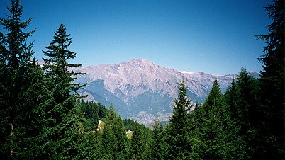
The road soon becomes small and within two kilometers it is an unpaved road into the woods. This is no problem as the road is very good for almost all the way (which is only about three kilometers) and it is lovely with occasional very nice views out between the trees. The first picture here is from one of those places on this unpaved road.
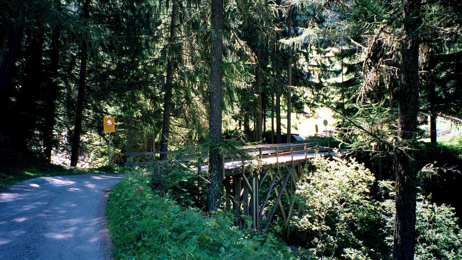
The next two photos (the one above and the one here) are taken from the same spot. The first looking ahead and just after the bend of the road the asphalt starts again. The other photo is looking back over the nice wooden bridge I had just passed and I nearly smashed up with a mountainbiker coming down in a very high speed on a path coming down just on the other side of the bridge (I think he continued straight down there). (There were plenty of nice MTB paths around here, with signs that did not say anything else than saying it was a walking or MTB path … .)
In the photo above in the next bend the road joined with the other alternative road you could take (and would have taken if all you had was Michelin maps). That other road is marked on all maps as either not passable or at least not as surfaced all the way to Haute Nendaz, but that is false – it is indeed a very well surfaced road all the way, but the road I took is much better as you will realize here (better views, shorter, less climbing involved and even less traffic).
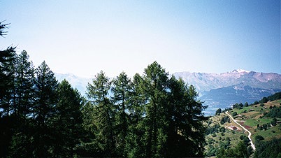
Nearly all roads that you could find on the maps on the Swissgeo website and on maps are surfaced, so there will be several alternatives roads that are possible to take at many places in the valleyside. The rest of the road to Haute Nendaz first climbs some hundred meters before it descends to the village. It is one of the nicest roads I have ever cycled on, with splendid views all the time, as evidenced in the next photo for example.
The road up the valley climbs when it goes around the sides of mountains and descends when it goes into small valleys inbetween. Thus the road is a continual up and down climb, occasionally even a bit steep.

The photo of the road looking up the Val d’Héremence and Val d’Hérens is one of my favourites. Good luck in finding the road! ;-) I think it was a road I reached after going up to Veysonnaz and past up on the highest crossing road until it dropped down to meet the road going up to Thyon – a steep road that I followed perhaps two kilometers (after stopping to eat some wild berries) before I turned off it to a closed road (only minor road work) (which was this). This road goes several hundred meters above Héremence (maybe the highest point on my way to the next pass at around 1600-1700 m). I turned back at the end of the short road and went down wrongly to a dead end at a farmers house. The farmer wished me luck in finding the way up the valley (I had to climb back up 150-200 meters again) and go the other way at the crossing. Well, somehow I never got down to the village of Héremence, but I got down on the road coming from that village further up the valley.
I went on the small road visible on the Michelin maps between the two valleys mentioned together above. It is a dangerously fast road in this direction!

Then I climbed up to St. Martin (almost a 500 meter climb and rather steep). The photo here is taken at the church at St. Martin – the peak you see just about visible furthest to the left in the photo is the highest and is the Dent Blanche above 4000 m.
I stopped at a little shop here that had just opened again and refilled my waterbottle. The small villages up here are very nice with ancient wooden buildings and not many tourists either.
Just before Mase there is a road going up again and I stopped to have a look of my printouts of the online maps of this area. A car with some older local people stopped to advise me not to go up there if I wanted to get to Nax. But, I was not interested in taking the easy way there and was not too interested in taking advice at that time. It was more exciting too see if I could find my way on the upper roads here, so I climbed up here.
Well, it turned out that the advice was probably good, but I was still happy with actually finding the way over here, eventually. I went wrong two times and climbed two roads up to where they ended in paths. Although I had to climb (also because of these extra errors) several hundred meters in a few kilometers and was probably up on heights around 1600-1700 meters again. I was actually up at Haute Nax (?) (despite that I knew beforehand that would be a dead end). I eventually got down to Vernamiège and Nax. On the way down there I took this photo here.
Now I was beginning to get a little tired. I continued to Grône and found the little road (after descending for a while!) going over Itravers to Vercorin – a very desolate little road and not the sweetest part of the way. After climbing up to Vercorin, where I stopped a little again. I decided to proceed according to plan and avoid the lower Valais valley for as long as possible, despite that time was flying away from me. It was rather easy to understand which road to take up the valley of Val d’Annivers. The road is okay here too and again very desolate. I took another photo (below) on the road up the valley and you probably see the Zinalrothorn at the end of the Val de Zinal. You see Vissoie down below (where I turned around back down later). A little further on this road one actually see the extremely big wall of the Grand Dixence dam (one of the highest laying dams in the alps) up the other little valley a bit later on this road.

Now, I went down from the valleyside finally as there is simply no cyclable alternative up this side of the Valais valley between Sierre and Turtmann. The road between Sierre and Turtmann was (of course) very busy with traffic and rather flat and boring. It was not a long distance though and soon I could turn off the road in central Turtmann and climb up the valleyside yet again. I wonder if there was not two alternative ways to go over to Eischoll and Unterbäch here – anyway, keep in mind that the road should go up and follow the Valais valley (you do not want to go up to Unterems, Oberems or Ergisch here if you are on your way to Moosalp).
Now I was getting really tired and had to think hard of whether it could be wise to try and get over the Moosalppass before the end of the day. I got some speed despite my tiredness (triggered by some other cyclists on the road). The road seemed very long and winding and I wondered if there could be a good place to stop along the road, perhaps in Bürchen, but even though I was very on verge of throwing the towel in for the day while arriving there and despite I knew I could break a new record in meters climbed on one day, I thought it did not look as if the place looked very hospitable to cyclists. I noticed tourists seemed to be hiring small houses in the upper nicer part of the village (as I heard some speak american).
The road up through Bürchen is very steep and it continues steep here and there to the top of the Moosalp (you never really get out of the woods on reaching the pass – the forest goes just that high here). If it was not enough with feeling extremely tired and having climbed a record meters in a day, now I also became very aware of my rib fracture (I thought it was some internal damage I had gotten until I came home again). The problem was when standing up on the bicycle and I really had to do that occasionally up here as it was killing me to sit all time. I could not use the arms at all while standing up on the bicycle it turned out and it was very difficult to stand up and just hang over the bicycle while climbing steeply. (I tried to stand on the less steep sections and sit on the steeper.) Eventually I reached the Moosalppass (2046 m) just before it got dark. I walked into the bar to ask the girls there if they knew of a place to stay for the night down the valley (they did not know much, but thought it was best I went down to Stalden). I first asked some people sitting outside, but it turned out they were from New Zeeland! :-) (Pardon for the mystical photo!)
I went down the nice road to Stalden (steep and narrow) which was a bit hilarious in the darkness, but nice. Down in Stalden I thought I saw some lights from up the valley of a possible hotel and just where the crossing is where you go either to Zermatt or Saas-Fee, a boring looking hotel is placed, called Killerhof. Perfect! They had a room and the lady made me a sandwhich with plenty of salami. It was reasonably priced and the breakfast was very good. Much better place than it looks like.
Day1 – Day 2 – Day 3 – Day 4 – Day 5 – Day 6 – Day 7 – Day 8 – Day 9 – Day 10 – Day 11 – Day 12 – Day 13 – Day 14 – Day 15