In the morning there were no breakfast and I was told no one would be there, so I just closed the door and took off. An old lady spotted me and wondered where I came from, so I had to talk a little with her before leaving. I had some pastries in a local café and took off in splendid weather again.
It was very lovely up in this part of the Valais valley. Soon I was down in Brig 660 m and had a little lunch at another café. I found out a bicycle shop in town (you better ask some locals on how to find it since it is on a backstreet). I guess it took an hour or so, but then I got help to finally change the front brake pads and the front tire. It was not very cheap, but it was necessary.
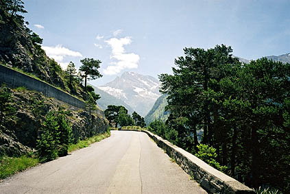
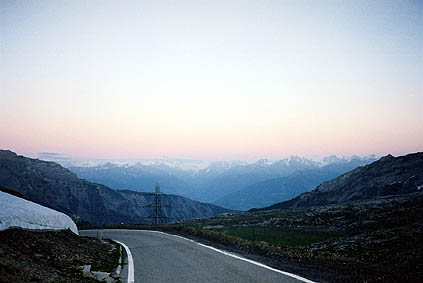
I took the old road up to the Simplonpass, which eventually lead you to the big road that must be used for most of the length to the pass. The first photo was taken high up on the nice old road. Soon hereafter it turned very hot, but it was more breathable up at the pass. It is indeed not a very easy pass as some may think given that it is a very busy main road from Swiss to Italy, especially if you take the steeper old road lower down.
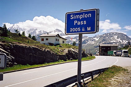
I went over the pass and down a little on the other side to see if there were some good views there, but they probably only improve further down that side at the Gondoschlucht.
There is good drinking water on the Swiss side of the pass height. There are also a couple of cafés up here. I guess it was 13 p.m. that I was at the pass. I now had to think over whether or not I could possibly do a pass this day that I had really hoped to do – the Gemmipass. The Gemmipass 2314 m is a very spectacular pass, but it is not rideable from Leukerbad 1401 m and up and would thus take quite some time. I was also determined to do the Col du Sanetsch this day. It seemed like it would not be possible to both and I decided to continue and make up my mind later.
Down in the main Valais valley it was very hot and heavy traffic. Then I also had a constant headwind. These conditions drained me of energy much faster than any pass climb could possibly do. I said to myself that it would probably be nicer cycling on a motorway in the suburbs of Los Angeles than in this hellish valley. Try and avoid the roads low down in this valley – there are higher roads on most places up on the mountainsides that are much better alternatives, even if they take much longer time.
I soon decided that I could not do both the Gemmipass and Col du Sanetsch this day. There were certain considerations in my plans ahead that made it a bad idea to wait with the Col du Sanetsch to the next day and I could not go back to make the Gemmipass either. I had to leave out the Gemmipass, which was sad and was one of the things that I had to blame the bad weather earlier on. This was the pass I most regretted not being able to do of the planned ones.
It felt like it took ages to get down to Sion and I was very tired upon reaching this town. I guess it took almost three hours from Brig and still it is only around 53 km. (I also stopped at a McDonalds on the way.)
At Sion 502 m I had some difficulty in finding the proper road up toward Col du Sanetsch. The Michelin maps are often very unhelpful on the mountain roads in the Valais valley (probably because they have not been updated for ages, even though reprinted). You should look out for signs talking of Savièze. The name is in fact on the map (1:200000), but it is not marking a special place and it is in fact a region of small villages.
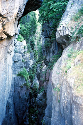
From Chandolin and up to the pass it is a very irregularly steep road that is very often very steep. I guess the maximum is around 18%. It is rather spectacular at first and it seems like a landslide very easily could overrun it. I had a photo at the Pont du Diable just before meeting the road up from Conthey to he pass. This road from Conthey is marked as being a path only on the last part on the Michelin map, but this is in fact the major road to the Col du Sanetsch. My guess is that this have been built as the major road since the other one is more susceptible to become unusable.
It was already getting late (and I who had thought of doing another very difficult pass this day as well – insane in retrospect). I passed by a hotel and soon again another one and got the ea that maybe I should be clever and book a room here and leave my package in order to have a more enjoyable climb to the pass and be sure I had a room upon getting back late. I stopped at Plan Cernet 1340 m and booked a room, left my backpack and got promised to have something to eat upon my return. It was now eight o’clock in the evening. After continuing up some steep passages, I realised I had forgotten to bring my lights with me. Jesus, I brought the front light with me on the trip mainly for this single pass as I knew there should be a long, murky, unlit tunnel near the top.
I did not want to go back as it would likely just be even darker then upon my return if I lost even more time. So I continued up and it was still a long ride left to Col du Sanetsch 2252 m. I could not see any tunnel above while going up and was hoping for some time that my information was wrong. Finally I reached the tunnel and it was indeed pitch black. I cycled a few meters in reluctantly knowing I would have to go off the bicycle and walk, but the suddenly lights were turned on by some sensor and it became a homey atmosphere in the tunnel and I was very happy.
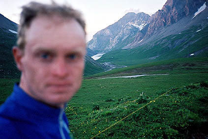
I reached the col sometimes after 9 pm and just before it got dark. It was very nice up there even if a bit cold. After taking two photos I went back down again, but this time I was not quite as lucky. There were no sensors in the tunnel from this side and it seemed like it would be futile this late to hope anyone else turned up going up at this time. The tunnel is never straight for long, but I had noticed that a little light entered the tunnel at a few places on the way up. The main problem was that it was almost dark outside now. However I had to concentrate on walking straight, slow and try to identify some extremely vague rays of light. I managed to have some sense of location apart from a short stretch were I had to walk with one hand against the side wall of t tunnel. It is 800 m and it took some time.
On the steep final descent that had many loose stones on it I had to guess where it was safe to cycle and tried to keep to where the car wheels would go. It went well and I had some pasta of my choice and dessert at the hotel by the friendly guy working there.
Day 1 – Day 2 – Day 3 – Day 4 – Day 5 – Day 6 – Day 7 – Day 8 – Day 9 – Day 10 – Day 11 – Day 12 – Day 13 – Day 14 – Day 15 – Day 16 – Day 17 – Day 18 – Next Day – Day 20 – Day 21 – Day 22 – Day 23