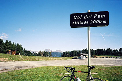
Perfect weather this morning in Mont-Louis and I had a very fine breakfast. I had decided to do a little loop around the higher places above Mont-Louis toward the Spanish border (where it is lower). I first went up to the pass most close to 2000 metres of the paved passes in the Pyrenées without reaching it even though the sign and many maps claims Col de Pam is 2005 metres high. Col de Pam (1997) is in the area of ski resorts and now in the summertime it seemed to be a somewhat popular recreational area with people training running and the like that looked very serious – I got the idea that this was a pretty ideal place for runners and many others to do some high altitude training. Col de Pam is a one-sided pass for cyclists.
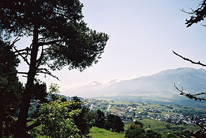
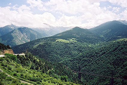
Just where you turn off the main road from Mont-Louis to Spain to reach Col de Pam (keep to the right), there is another col named Col du Calvaire de Font Romeu (1836), which is the highest point on that road. When reaching Font-Romeu, soon after the col, I guess I took the second or so … road to the right up the mountainside as I had spotted a seemingly paved higher alternative road on maps and guessed which one to take (no signs of much relevance in this area). It was the right one and it is soon very flat and offers splendid views over the wide valley and distant peaks. The second photo is from the high point on this road.
One reason for taking this higher road was that it should connect higher up on a road leading to another col named Col de Bec/Coll de Bes (ca. 1700). This col is not recognised by the Club du Cent Cols, since it is not clear that there really is any true col there. A person living nearby pointed out the place though and it is on a couple of official maps and even the road there is called 'Rue du Coll del Bes' (the Catalonian name). However, it did not look very much like a pass to me either. The last bit of road up there was rather steep!
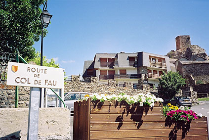
Rolling down to the main road again takes you to a crossroad and another col – Col de Fau (1635). Here was a small shopping centre and I stopped to have a sandwich, pastry and a coke. Then I crossed the main road and headed down to the bottom floor of the valley, passing Col d'Egat (1615) and Col de Palmanill (1512) on the way down via Estavar and toward Llívia (1199).
Llívia is an enclave totally inside France but belonging to Spain. I had not heard about such a place before I started planning my trip. It is just a hill, some farmland and a busy village where there seemed to be more construction work going on than in the rest Europe together. Probably they have some good terms for living there or it is simply a very popular place to move to among spanish people and all buildings were built in exactly the same style (brown wood and stones) apparently after some original farming style. Looks cute, but comes across more plastic than Disneyland here really. (It is the same in much of the northern part of Catalunya. It seems like they attract the moderately well to do from down in Spain to these more green and breathable areas (but also rainy and foggy).)
I quickly escaped out of this place via a road that turned into a dirt road and at the crossing back to France was really only practicable with a farming tractor (only very shortly had to walk though). I had to cut short and skip some of the planned cycling in this area. I had planned to go up to the Coma Morera mountain at the border and at least visit the paved pass Col de Pradelles (1985) and take a minor route down to Mont-Louis.
I took the other main road in the valley back to Mont-Louis and this is the lower and most used by heavy traffic, but despite this it has three cols instead of two on the higher road. The three cols I passed were Col/Coll de Llous/Llus (1336); Col Rigat (1488); and Col de la Perche (1581). From Saillagouse it should be preferable to go via Llo and Eyne to Col de la Perche and take in the Port de Llo (1579) col instead of the Rigat col.
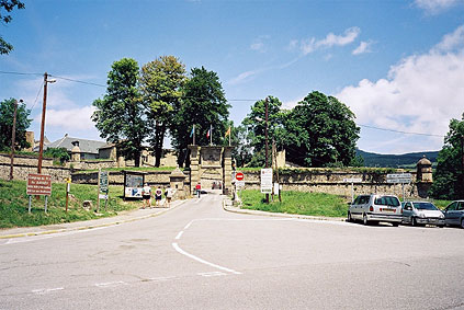
I stopped at Mont-Louis to have a photo of the only entrance to the city. I had tried in the morning to go out via the back side which is higher and closer to the beginning of the road I wanted to go out on, but was told to return by guards! (Okay there was a sign, but I was a doubting the fortification was really that strictly guarded.)
The road down the valley was quick and fun to ride. I stopped and had one photo. It shows (not so very clearly) a very big train bridge below where the Traine Jaune goes up the valley to Bourg-Madame. Apparently it is possible to continue with train down in Spain or in a long tunnel under the Col de Puymorens pass and then down to Foix and further.
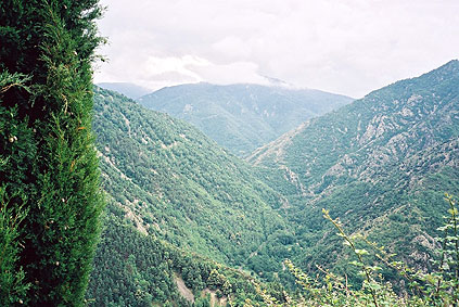
On the way down the main road I took off at the first road that makes it possible to stay out of the main road for quite some time. It starts out some time after Olette, but before Serdinya. It is a very narrow and little used road that is mainly for the little village of Escaro. But one could get north here and over Col de Fins (897), where the next photo is taken, to Sahorre (674). It is a pleasant and quiet road. I was planning as the main attraction for the day to cross over the highest mountains in the east of the Pyrenées – the Massif du Canigou – by a gravel road known to be difficult. I made a somewhat bad choice (probably) of road to take by starting to climb the road up toward Py and Col de Mantet (where I possibly should have gone instead). It is a nice road, but then I had to take a very hard gravel road over to the start of the gravel road climb over the Massif. (I could have gotten to that starting point by using asphalt roads, albeit a little longer longer.)
It was only a few kilometers over to the Canigou road, but I got very tired of fighting my way up there and then I noticed more clearly all the time the luring clouds above covering the traverse and making me worried I would miss out on this gravel high point also with several +2000 metres cols above. Then I met the asphalt road where the asphalt runs out, which is another col called Col de Jou (1125).
I started at once to climb up the much better gravel road here and passed by (not obviously) Col de Creu (1200) and then the gravel road got very steep, so even if it was still better, it was again a hard struggle to get up. A 4-wheel car with four people came down and they stopped to talk a little with me. They understood I wanted to get up to the top and wanted to advice me that it might not be such a good idea as I would enter the clouds at around 1700 metres and they said that if I did not know the area it would be very easy to get lost at the top, which is very much like a big plateau with gravel roads running in several directions. They suggested the chances were that I might very well go in circles up there without visibility and about the possible rain/thunder they were as undecided as myself as to the chances of escaping that.

I had a photo sometime before arriving at Col de Jou to indicate the lurking clouds and situation up in the mountains. I should obviously (in hindsight) had gone up there right away in the morning (that's usually the case for difficult roads or places where weather could be very important is involved). I got some water from them and continued a little bit further (a bit above 1300 m only I think), but then decided that this might become the adventure I was not really up to facing at this point. My emotions told me to go on over the Massif, but reason decided otherwise and I was very unhappy about going back down, but tried to cheer up a little anyway. Damned, I have become too cautious! This doesn't make for good stories to be told!
Well, nice good asphalt roads are always enjoyable and the road from Vernet-les-Bains (620) over Col St Eusčbe [66-0795) and Col des Millčres [66-0842) to Prades at the main road, was a super road for road bike cycling! It was a twisting and entertaining road mostly downhill to Prades. (Col des Millčres is not really on this road, even though a sign suggests so, but is just 200-300 metres up the little asphalt road from the sign. The asphalt runs out at the true col, where a camping also is situated. This road is the direct approach for those wishing to get up on the Canigou peak itself.)
At Prades I got irritated that I could not get anything to eat. Half past five (I think it must have been) is not a good time trying to get something to eat in this part of Europe – I found an open McDonalds outside town and came up in my bitterness with the idea that all that French culture has to offer is McDonalds and if the frenchmen says that is not French culture, I would have replied that then they obviously have no culture at all then. You see, I was not very reasonable, but luckily I did not come into discussion with anyone at this or other times when I felt similarly (yes, it happened a few more times).
I simply had to cycle around the Massif du Canigou now instead. That is not so very simple though. It is after all a pretty big mountain group. But it had helped to get a bit angry before and now I was just to quickly go around these mountains in the evening. I stopped again at Bouleternčre and had something more to eat and drink as it was time for the shops to close down (7 pm). There are two cols on the main road I passed: Col St Pierre (240) and Col de Ternčre (233). Bouleternčre (180) is only about 20 km from Perpignan and the Mediterranean sea.
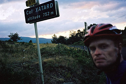
The road ((D618) that I followed all the way to Amelie-les-Bains (which was not on the map that I had scissored out) was quite long, nice, quiet and with no sign of any restaurant, shops, water, etc. I saw a church and a few farmhouses along the road, but that was about it. It is quite a nice road, but with slightly harsh surface. I went at a really good speed and was rather exhausted when I reached the first col along the road – Col Fourtou (646). This is at a crossing. I continued up to the highest point on the road, which is the Col Xatard (752). I found out while checking a map the day after in a shop that I had also passed Col del Rang (Fang?) (655) and Col del Ram (668) between these two cols.
It was nice sweeping down the curvy road to Amelie-les-Bains in the late twilight (almost dark and I was hurrying). Many hotels in Amelie-les-Bains were closed and I reluctantly stayed at the most busy night-open bar in town that had rooms (Hotel Paris?). (No good place for the bicycle, but it did not get stolen. I have no locker.)
Day 1 – Day 2 – Day 3 – Day 4 – Day 5 – Day 6 – Next Day – Day 8 – Day 9 – Day 10 – Day 11 – Day 12 – Day 13 – Day 14 – Day 15 – Day 16 – Day 17 – Day 18 – Day 19 – Day 20 – Day 21 – Day 22 – Day 23 – Day 24 – Day 25 – Day 26 – Day 27