Dillon is at the base of the Loveland Pass (3655m). The day started with a good breakfast at the Best Western hotel and it had just dried up outside since yesterday’s rain. It was a normal sunny morning here. The route over the Loveland Pass was just lovely and a bit steep this time. A man sat by a roadside parking place playing a big tuba instrument (I heard him at a distance and wondered what it was). A bit odd, but nice.
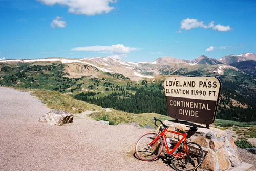
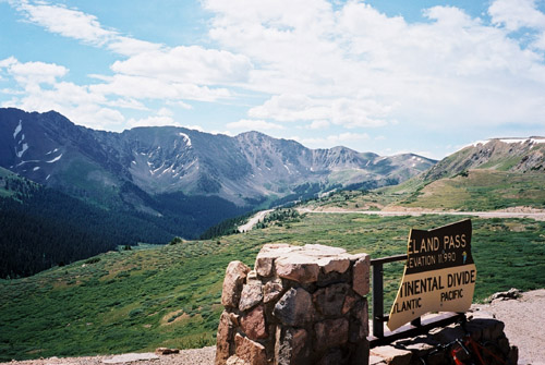
I was surprised that even big trucks went over the actual pass rather than through the tunnel below, but maybe they carried some chemicals that was not allowed to bring through the tunnel. The traffic was moderate and not a big problem at all. The pass itself is very nice as evident from my two photos here. The east side of the pass is a little steeper, but also shorter. It was a very fast road down to the junction with the interstate I-70. From there you have no choice but to cycle on this big motorway with lots of traffic. It is not a big problem as the road continues somewhat steep down here to Georgetown and I was rolling down at an average above 60 km/h. (Now I understand clearly why Michael Seeberg, in the book earlier mentioned, recommended to go over this pass in this direction.)
I turned off at Georgetown and bought a cookie & coke at a gas station. Then I followed the alternative road down to Idaho Springs, which is pretty bad in the first part, and near Idaho Springs continues as a bicycle path to a dead-end. I returned under the motorway into Idaho Springs and at once started out on the road going up to Mount Evans. Unfortunately, since I was here a bit late (like 2 pm) I knew the chances that I would encounter bad weather as I got closer to Mount Evans was a very obvious possibility. It was indeed very unfortunate that I was this late here, but I couldn’t have climbed over the Loveland Pass the day before, I think.
However, going up to Mount Evans – the highest paved road in North America was perhaps the number one goal for this trip and I was just going to try and get there no matter what. I was cycling somewhat slowly up as I knew it would be a LONG climb and it surely was! It is around 28 miles (45 km). There is not one mile of the road with an average inclination above 6.5%, but due to the height it feels much harder.
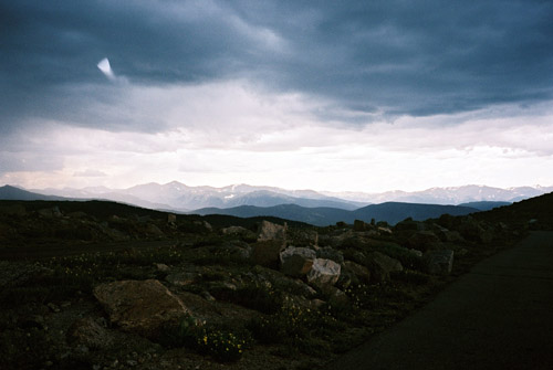
I had already noticed clouds starting to gather on the way down from Loveland Pass and when I saw the first glimpses of Mount Evans on the way up, I noticed clouds had already gathered up there and had started to look greyish. It dampened my spirit a bit, but I kept going. After Echo Lake one arrives at the toll booths where I had read that one had to pay a fee even as a bicyclist (and I have found no contrary mention on the web). So much to my surprise they told me that I did not have to pay if I was not going to stop along the road! Kind of funny obligation!?! I asked if that meant that I could not stop for a photo? She said that I could indeed not stop to take a photo. I said ok, I will not stop then! Then I wondered where the guards watching my eventual mis-steps would be placed along the route ;-). I assumed the idea was not to be in the way for all the tourist traffic, which was not immense this day as the weather was getting gloomy now.
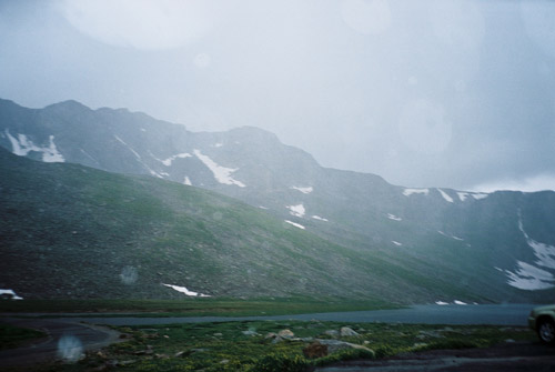
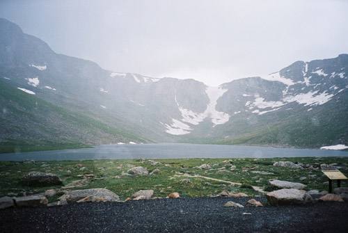
I continued up and the height was starting to make it clear this would be a hard, slow climb. When one comes above the trees, the views get magnificent! After a while it started to rain and I had to stop to get my wind/shower jacket on. That went well (they can fine me on the way down, I thought). The rain shortly went away, but upon reaching the Summit Lake (13,001 feet/3963m) the rain started again. I passed by Campion Pass (4018m) a bit above and then started out on the last series of hairpins, but then the powers of the sky gathered to make life as miserable as they possibly could for me. Thunder and lightening was all around me now and very close by. It rained more heavily and the wind got stronger. Then I had a terrible hail-storm with big ice cubes smattering down at me, making me totally forgetting the altitude problem. I struggled on and people took photos of me while passing me by on the way down in their cars. A motorcyclist slowed down to warn me that it was snowing at the top and that I should perhaps turn around. I was so close to the summit (14,130 feet/4307m) now, but it kept getting increasingly harder to get up for every hairpin even though I felt fine physically. After a while I gave in and reached out my thumb at a van coming down and they stopped at once and had my bicycle in the back of the van and I went back down safely with them.
It was apparently only four turns left until the top – just some hundred metres – oh damned! I guess it was around 4200m where I stopped, but this is anyway for me a cherished height record! It was the sensible thing to do to abandon this attempt to reach the summit – all I can tell you is that you would have agreed if being there! The main reason for giving up was the lightening being so close and I felt it was unnecessary and vain to continue with a high risk of getting too close to a lightening bolt. Also, the hail-storm only got worse and I would likely not have gotten any good photo from the top in this weather. It was just so expected that it would become like this!
The couple who picked me up was a very nice couple from Golden (relocated from Michigan, I believe) who actually took me down all the way to outside Golden on CO 93 in an attempt to escape the rain that engulfed the whole area quickly. Very nice of them! I managed to bicycle a few kilometres in the direction of Boulder before the rain came crashing down on me (that is a good way of putting it because I was almost driven off the road by the furious rain).
Really soaked I turned off the Golden-Boulder road and started to climb back up the mountains on CO 72 and now escaped any rain (very narrowly escaped it). The road has no shoulder and I had some traffic here, not leaving much room for me. But the climb was somewhat hard, long and varied. There was very nice scenery higher up on this road around Pinecliffe. As I turned in on the Peak-to-Peak road that follows the Rocky Mountains by their feet over to Estes Park, it started to rain again. Now I was close to Nederland and it was also starting to get dark. It is far between places where one could stay for the night up here, but I got the last available room (maybe they always say so …) at the Best Western in Nederland (which was not so good).
After having a shower I tried to get something to eat, but the nice-looking German restaurant was closed for the day and the place they assured me was open was also closed, and I was directed to a very simple looking bar with only one guest. They were not hip, but good for all purposes and with the best prices I have seen in the US. I got a cheeseburger deluxe carefully made and served with chips – yes, it was this kind of place where they do not even have fries. It costed $4.25 or similar. The draft beer costed only $2 for a big glass and I had two of the nice ‘54’ beer. I asked about the beer name and it was named after the 54 +14,000 feet peaks in Colorado. So I mentioned to the other nice guy in the bar that I just visited one of them, so it seemed like a good choice now. (90 Shilling (a dark one) was the favourite beer I found in Colorado, but they do have a lot of good beers there.) Thereafter I went to have a pizza at a pizzeria that I was recommended not to try, and they were not too good and played death metal on highest volume (real trashy countryside style ;-)).
