1433m - 24.2 km (Brixen/Bressanone via Eores/Afers)
1325m - 18.6 km (Villnößtal/Val di Funes via Russiskreuz)
[IT-BZ-1863]
 |
Height | Climbing height - length |
| 1866m | 1300m - 26.3 km (Brixen/Bressanone via Lüsen/Luson/Lijun) 1433m - 24.2 km (Brixen/Bressanone via Eores/Afers) 1325m - 18.6 km (Villnößtal/Val di Funes via Russiskreuz) |
|
| Difficulty | Beauty | |
| 3-4 (5) | 4 (5) | |
| How to get there | This pass is very seldom used without also crossing Jù de Börz/Würzjoch/Passo delle Erbe (1993m) and in some cases Russiskreuz/Sella di Russis (1729m). The only way to avoid those passes is to start and end at Brixen/Bressanone (560m), oddly enough, and it is thus of little practical concern on its own. The shortest (because there is no dip on the way) climb starts where the Villnößtal/Val di Funes starts (above Klausen/Chiusa). This is probably the hardest climb, but all have steep sections. The roads are very good here. | |
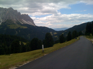
| Other comments | It is a very nice pass to climb from any direction, but the best thing is to visit both Würzjoch and go over Russiskreuz to/from the Villnößtal/Val di Funes. There ought to be water on the way in the villages. There is also a nice road up to the Plose mountain north of here to 2029m and then a gravel road that turns less good the further up you get. I managed to cycle with my road bike to the 50m walk to Lüsner Scharte/Forcella Luson (2383m) in 2003. Apparently Éores is the Ladin name, but has been prefaced by the italian ‘Passo di’ on maps. I try to go with local names first if the passes are not that well known by people from afar or by the sign, if there is any. Apparently locals call it mostly Kofeljoch, though this is the name least often mentioned on maps (but appears on the popular TCI map). Halsl is not known by some locals, but seems the most correct name and the hütte at the pass is named after it. The Rodella name is the fascist IGM name. (Photo taken at a crossing just west of the pass.) [IT-BZ-1863] |
|
| Map |
||