984m - 36.1 km (Pians); 1099m - 42.1 km (Landeck)
133m - 3 km (east fr. Bielerhöhe); 674m - 8.4 km (west fr. Bielerhöhe)
[AT-7-1842]
|
Height | Climbing height - length |
| 1842m | 1264m - 38.8 km (Bludenz) 984m - 36.1 km (Pians); 1099m - 42.1 km (Landeck) 133m - 3 km (east fr. Bielerhöhe); 674m - 8.4 km (west fr. Bielerhöhe) |
|
| Difficulty | Beauty | |
| East 3 (5); West 4 (5) | 4 (5) | |
| How to get there | You can start at Landeck (788m), but I would recommend going the way via Tobadill (1148m) and Trisannabrücke (886m). You would start near Pians (858m) if coming from Arlbergpass (1793m). You go up the Silvretta road to Galtür (1582m). From just above Galtür there are two alternative roads to this pass and both of them are asphalted. The lower, smaller and steeper one starts just above Galtür in Wirl (1622m). The wide and easy toll road starts higher up (1709m) (there is no toll for cyclists). The road from the west has recently been asphalted too and is a much steeper and harder climb to the top. This climb starts in Bludenz (578m) and one turn off the Bielerhöhe road at the first hairpin (1168m). | |
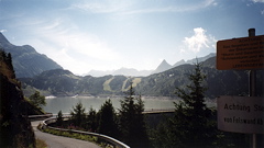
| Other comments | There are beautiful views, seen in the photo here across the Stausee Kops (dam), ca. 1 km after the pass on the west side. See also: Bielerhöhe (2037m). [AT-7-1842] |
|
| Map |
||