1069m - 16.2 km (Troistorrents)
|
Height | Climbing height - length |
| 1809m (road height 1813m) | 1391m - 20.8 km (Monthey) 1069m - 16.2 km (Troistorrents) |
|
| Difficulty | Beauty | |
| 4 (5) | 3-4 (5) | |
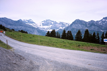
| How to get there | The climb from Monthey (422m) is a bit steep at first on the wide and busy road to Pas de Morgins/Col d’Abondance (1370m), but when you turn off at Troistorrents (744m), the road climbs slowly and sweetly up through Val d’Illiez. At Champéry (1044m) you go up right through the village and then stay on the main road, when the road goes up in a hairpin, you should go straight on the route de Planachaux. As I was coming down to Planachaux from a gravel road, I do not know whether the road is well sign-posted. It should be steep (14%) soon after the road leaves Champéry. At the actual pass it is gravel (good), but by turning right near this point you could reach the ridge at a similar height on asphalt (or so it looked from nearby). Looks like 285m gravel from the end of the asphalt road. | |
| Other comments | The road that descends to Les Crosets is only good enough for MTB. But the road that circles around Les Crosets at roughly the same height all the time is good enough for a road bike, but gravel to and beyond Pas de Croisette (1820m). Similarly one can go in the other direction on the high level gravel road to Les Pas/Col de Ripailles (1824m). The road from the route de Barme to this later pass is very steep where it climbs up from the valley below and is not really usable with a road bike for ca. 1-2 km. See: Col de Barme/Seuil du Sex Blanc (1621m). One could probably get up to the station (1930m) by the Croix de Culet (1963m), but I have no information that verifies if it is all asphalt or not (the views should be even better from there). | |
| Map |
||