990m - 12.9 km (Niedervintl/Vandoies di Sotto)
990m - 12.1 km (Niedervintl via Sergser Strasse)
988m - 12.2 km (Mühlbach/Rio di Pusteria)
988m - 13.3 km (Mühlbach/Rio di Pusteria via Meransen)
This pass will surely not make you gain any time in reaching your destination, unless the destination is somewhere near the pass itself. But as the ride itself is the goal for most cyclists, this should be a good choice of road to visit. You start in Pustertal/Val Pusteria preferably at Niedervintl/Vandoies di Sotto (756m), where you turn off the main road in the valley and continue up to Weitental/Vallarga (860m), where the climb begins. It is a sometimes very steep and narrow road. It dips a little at one place higher up before it continues a little less steep until the top. Maximum steepness is probably around 17-18%. It is a very beautiful road with good views up most of this side, but the last part is mainly in the woods and the top is a very boring place.
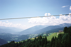
Just after the top a wide and very good road, that is less steep, goes down first in the woods, but soon with very wide views down over the big valley and mountains surrounding the Brixen/Bressanone area. From the west the climb starts just a bit further down the Mühlbach/Rio di Pusteria (758m). The road is mostly wide and always very good on this side and never steeper than around 10%. I noticed a more direct road bypassing Meransen, which would be steeper and could be a good idea to take if climbing this side (see the map). Directional signs refer to the pass height as ‘Kiener Alm’. There is also a road (Serger strasse) which shares the eastern climb start in Niedervintl but that takes you around the mountain to reach the pass from the west side
[IT-BZ-1741]