Sign 1750m
1214m - 9.70 km - 12.6% (Ovaro south)
1255m - 10.18 km - 12.4% (Cella)
1056m - 8.20 km - 13.0% (Liariis)
1205m - 13.23 km - 9.1% (Sutrio)
1217m - 13.62 km - 9.0% (Sutrio south)
1157m - 8.80 km - 13.3% (Priola)
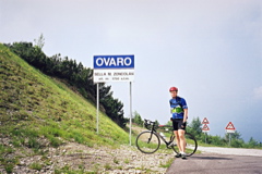
This is one of the hardest climbs in Italy and elsewhere. The classic climb starts from the west in the village of Ovaro (531m or 525m) or further down by the river (Torrente Degano) at the bridge from Cella (484m). This is a southernly alternative passage east south of the Sella Valcalda (950m) (which is the most northern asphalted passage inside Italy here). This climb is very hard from just after Liariis (682m) with an average of ca. 15% for the last 6 km. Maximum is a little above 20%. There are three unpaved (now paved) and unlit tunnels near the top where it is not so steep. This approach to Monte Zoncolan has been resurfaced in 2007 and improved since it became obvious that the Giro d’Italia only climbed the “easy” side back in 2003 and they now returned to tackle the hard side!
The climb from Sutrio (533m or 520m) to the east is on a wide and smooth road up to a parking place (1300m) by the ski resort on this side of the mountain. It then continues on a very steep and narrow road similar to the west side until the top. There is an alternative road on the east side that joins the other road after the parking place (1324m). This road starts in Priola (581m) and was first fully tarmacced in October 2005 according to a good report by ‘Renko’ at quaeldich.de. This road is nearly as hard as the Ovaro climb and is partly hard because it usually has more debris on the road and drainage gullies that one has to handle, but there is virtually no traffic and the obvious choice climbing from the east.
The climb from Ovaro is so steep that after Liariis it is difficult to find possibilities for drinking. 39-28 is a minimum for these type of climbs. At the top there is a surfaced road going off to some ski lift stations, but it reportedly does not go anywhere (I mistakenly started out on this while there in 2004, but returned a bit later). There is water just before the real climb starts soon after Liariis. The climb is mostly wooded and offers few good views on either side. You could start the climb in Liariis if coming down from Clavais, but the road to Clavais from the north is quite badly asphalted (to Clavais).
This climb could be combined with the climb to Panoramica delle Vette (Monte Crostis) (1982m) via Tualis on the other side of the Valcalda pass, from where you have great views to Monte Zoncolan. The road to Malga Arvenutis (1513m) via Lenzone is asphalted all but the last 275 flat metres (1513m) – 12.2% for 8.47 km from Cella (484m via short-cut) and is a great alternative climb to Monte Zoncolan, but it lacks good views even more.
[BIG 720]