1329m - 20.4 km (Utelle road)
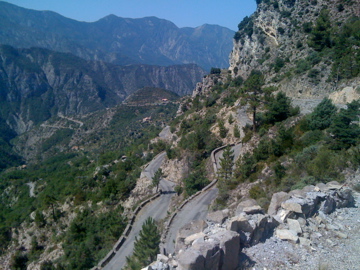
This climb properly starts at Pont de la Lune (233m) in the Tinée valley, just a bit up from the start (187m). It is a nice regular mountain road up to La Tour (603m), where a very narrow road starts winding its way up the mountainside. It goes in seemingly mysteríous ways and you do not have much of a fair chance to guess at where you are really heading. Eventually there is a long flat section and you now get a little shade, which could be welcome as this could be a relentlessly hot climb in the Summer. Then it goes steeply up in the woods to the pass, with mile stones suggesting you have already reached over 1700m before arriving at the pass itself, but they could not be correct, but you will want to believe them.
Another possibility is that you come here via the road to Madone d’Utelle. That would be similarly hard with ups and downs before starting the climb at ca. 355m before La Tour, where you would meet the normal road just where the small road to Les Granges de la Brasque starts. It says nothing on the climb about Col d’Andrion before you arrive there. This is because the end of the asphalt road behind the pass is the Granges de la Brasque (old military buildings).
The eastern alternative roads to the pass are of varying quality and it could be hard work with a road bike even if you manage to pick the best alternative, but it looks possible and I know people have ridden this side with a road bike too (but I might still be faster going back and over Col Saint-Martin (1503m)).
[FR-06-1681]