868m - 21.8 km (21.1 km - 888m - Col des Mosses) (Les Moulins)
1003m - 28.9 km (Montbovon via Hongrin)
1466m - 26.7 km (Yvorne via Ayerne)
1241m - 18.5 km (Aigle)
581m - 6.7 km (Le Sépey)
715m - 8.9 km (Les Planches)
621m - 10.9 km (Les Voëttes)
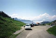
Looking closer on the pass, I realised there are a surprising number of alternative ways to climb this pass, even if there is only one asphalt road down each side of the pass. I believe I took a somewhat easy way to the pass myself on my single visit as I see there is another more direct road from the south that looks all asphalted (as far as I can tell) and I was coming from Les Planches (943m). The last stretch on both sides of the pass are quite steep, but steepest on the north side where it was up to 20% on a short gravel section, that I believe has been asphalted now.
The climb from Aigle (417m) should be the most consistently hard climb up here. The climb from Yvorne (409m) should ultimately be harder though even if it is downhill after Les Agites/Les Cases (1554m) to Col d’Ayerne/Col de la Jortèse (1466m) and then a little more down until the steep road up to the pass.
If coming from Col de la Croix (1776m) or Col du Pillon (1546m) you can start at Le Sépey (1077m) or take the nice little road over Les Voëttes and start at 1110m. Or you can start in Les Planches if coming down from La Forclaz (1261m), like I did.
You can also start the climb in Châteux-d’Oex (902m) or Les Moulins (890m) and go via Col de la Lécherette (1389m) and then either follow the lake and climb from the more logical north side, or go via Col des Mosses (1445m), which is actually shorter and might even be easier despite climbing another pass on the way. Or you can take a small road from Montbovon (798m) via Allières (with maybe a short stretch of gravel) to the Hongrin dam and go around it to continue climb the same valley up to the pass!
[CH-VD-1661]