1149m - 33km (1678m - 38.3 km (Bärgli)) (Landquart via Küblis)
821m - 12.2 km (1350m - 17.5 km (Bärgli)) (Küblis)
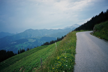
This pass is located on the road to Bärgli above Küblis and St. Antönien. Up to Küblis from Landeck (529m), the road is only slowly climbing, but from Küblis (808m) the road up via Pany is quite steep, but then flattens out and even descends a little as the road continues to St. Antönien. It is best to go through the village and take the normal road up to the left somewhat steep again to the pass. Continue at least up to the end of the road bend (1652m) above where the asphalt changes into a slightly rougher surface. Here you have nice views.
Obviously it is nicer still to continue to the end of the asphalt road to Bärgli (2137m), with many signs along the road trying to suggest it is a hard climb for people taking part in a bicycle event up there (might disappear eventually), but the climb is not so terribly steep, but rather long! You could indeed also start the serious climbing before getting up to Küblis (if coming from Landquart), just above Schiers (670m) where a narrow road climbs steeply, but then it is almost flat for some time over to the road to Pany/St. Antönien.