Sign 1590m
1267m - 21.6 km (Bellori)
1524m - 32.3 km (Mizzole via Cerro)
1626m - 33.8 km (Mizzole via Velo)
1537m - 32.7 km (Mezzane)
1348m - 29.1 km (Marcemigo)
1215m - 24.3 km (Badia Callavena)
1062m - 20.3 km (Bernardi)
This pass could be reached from many different starting points and I had to limit myself somewhat to what seems like the steepest/shortest and roads best connected with other passes. If we start from the southwest side down near Verona, you could start the climb at Stallavena (246m) (some choices of roads here, but see the map for the shortest/steepest one) or higher up from Bellori (339m) in Val Pantena straight up from Verona.
You could alternatively climb the long Valle di Squaranto on a minor road from Mizzole (Montorio) (82m) via Cerro Veronese and meet the other road at Bosco Chiesanouva. Notice the turn-off before the pass for Bocca di Selva (1556m), which is a nice extra or alternative climb here. From Mizzole you could alternatively go up the other side of the pass by going via Velo Veronese, which is slightly longer.
You could start in Mezzane (141m) and climb the long ridge via Passo dello Spin del Poiero (895m) by Monte Moro (no sign) and up via Velo Veronese to the pass. You can start on the other side of the ridge in Marcemigo/Tregnago (330m) and climb the same way up (once you reach the ridge road SP 16).
Further up Valle d’Illasi (a great place for cycling many days up different nice roads), you could leave the valley at Badia Callavena (449m) and take the more direct SP 36a up to the ridge road (meeting it above the Spin del Poiero pass). Finally you could take the road up from Bernardi (602m) that I used on the way down when I was coming down from the pass. This is the place to start at if you have travelled over the nice Passo Gioichè (1146m) from the east to here. Here you meet the ridge as Velo Veronese and then continue straight up to the pass.
The road up the Valle d’Illasi to Passo Pertica (1522m) looks interesting, but unfortunately it turns to gravel when reaching the Trentino border a bit earlier, but it might well be possible to do on a road bike (looks like typical mountain bike road with a little too much small stones for road bikes) and the road above to Passo Pelagatta (1776m) seems to offer fantastic views, but the road is likely even worse with a road bike there.
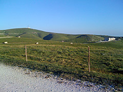
The photo here was taken above the pass (almost in the direction of the pass) on the famous Lessinia gravel road (usable with a road bike). I can very much recommend trying the Lessinia road which is gravel (11.4 km) from above Bocca di Selva (best way to go to/from) and all the way to Bivio del Pidocchio (1565m), where you could go down via Bocchetta della Vallina (1487m) or go to Passo Fittanze (1380m). High point of the road is 1707m.
Both Passo del Branchetto and Bocca di Selva are vague as passes, but the Branchetto is at least the high point of the road and it is 4m higher outside the road. There are much more obvious passes around here without names (see the gravel ridge road above), so guess we have to be happy with these.
[IT-VR-1586]