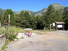
Signs 1545m, 1540m
1307m - 26.9 km (Montalto)
1388m - 30.5 km (Badalucco)
1938m - 44 km (Poggio di San Remo)
2124m - 49.9 km (San Remo)
2242m - 51.5 km (San Remo W)
2207m - 53.6 km (San Remo/Ospedaletti)
2233m - 51.7 km (Ospedaletti old)
1265m - 17.9 km (Pigna)
1404m - 26.8 km (Isolabona)
1857m - 39.5 km (Isolabona via Monte Ceppo)
So many places where one could possibly start this climb, but let us mention the most obvious ones. Up from Arma di Taggia by the coast in Liguria one could start the climb before Badalucco (155m) if coming down from the Monte Ceppo road (one could also go up here via Monte Ceppo to the pass). If coming down from Colla d’Oggio (1060m or Passo del Conio (1147m), you start from Montalto (236m) and climb via Molina di Triora (444m), where you would have started if coming down the Passo della Teglia (1385m) (a road that takes time between when they improve the pavement).
From Colla Langan (1124m) you take a small road and pass by Colla/Colle Belenda (1383m) and have some nice views before reaching Colla Melosa, where there is a rifguio and another hotel (stayed at the hotel, but guess the rifugio might have been the better choice). The road soon turns to gravel after the pass unfortunately as the road above looks exciting, but the gravel seems a bit too bad for road bikes unfortunately.
You could start down by the coast, but it would be more logical then to start at Poggio di San Remo (12m by the coast) and I only show the very steep approach on a concrete road to Poggio (I only did the more classic and easy eastern variant myself when here). This road takes you straight up to Passo Ghimbegna (892m) and from there you take the Monte Ceppo road (actually just before this pass that takes one to Bajardo (851m)). This road is a bit washed out but a nice way to Colla Melosa over Croce di Presto/Pian del Vento (Monte Ceppo) (1501m) and a descent to 1094m before Colla Langan (1124m).
You could start also in San Remo (5m), but from here it is a bit longer as you go via San Romolo and Conca di Bignone (1065m) to Passo Ghimbegna and follow the same road as before. Longer still would be to start in one of three places in Ospedaletti and one from San Remo west (9m). This last one is a straight road up to Coldirodi (probably the older direct road) rather than the simpler big road up this side, so this looks like a steep start on this climb. The road from the border between San Remo and Ospedaletti SP80 (44m) has many hairpins early on, but this road does not seem very steep.
You could however start at the most western starting point in Ospedaletti (18m) (you will need to consult the map here) and take the Via Ospedaletti to Coldirodi as I did when climbing Monte Ceppo and Colla Melosa in 2013. The road to Coldirodi this way is however quite steep with at least one long ramp much over 20% on a narrow road and the last stretch might be testing too before you arrive at the centre of the village. You have to look on the map carefully again if you want to get out the most obvious way up, but now it will be easier. All these three last options meet up on the road that goes to Colle Termini di Bajardo/Galleria Brunengo (896m), but you turn down to San Romolo a little before this tunnel and follow the same Bignone road to Passo Ghimbegna as when going from San Remo centre.
If coming from Ventimiglia, it would be more obvious to go via Dolceaqua and here I choose Isolabona (99m) as the starting point as you here could alternatively go via Bajardo and Monte Ceppo too, as well the direct road via Pigna (278m) to Colla Langan, which would be the steepest road to Colla Melosa, but probably not the hardest of the climbs listed here.
[IT-IM-1540]