542m - 13.5 km (Martina/Martinsbrücke)
609m - 21.3 km (Glurns/Glorenza)
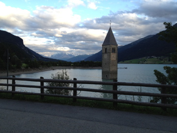
This pass is (in)famous for the church buried in the Reschensee dam, the building of which destroyed the old village of Reschen and let only the church tower stick up through the water as a reminder of what once was there. There is a old fort on the north side at a narrow passage which likely made the road over Norbertshöhe an attractive alternative road in older days. The views are most open on both sides of the pass and it is therefore a rather beautiful pass.
Due to irrational local road politics, the main road (even if no motorway and for no apparent reason) is forbidden on the Austrian side on the parts where it is safest for bicyclists to use the road and you will therefore have to climb a bit extra on small alternative roads until you are allowed out on the less safer parts of the road again. On the Italian side you are encouraged to stay off the easy and safe main road (with not too much traffic) and use a bike path, which is fine in parts (at least the one suggested in the map below up from Glurns/Glorenza). The road on the other side of the Reschensee is a good alternative road with less traffic, but with some more climbing. You could also from Reschen (1500m) climb up to Schöneben/Belpiano (2113m).
[IT-BZ-1507]