1262m - 17.5 km (Valdobbiadene)
[IT-TV-1502]
|
Height | Climbing height - length |
| 1499m | 1241m - 17.8 km (Valdobbiadene Est) 1262m - 17.5 km (Valdobbiadene) |
|
| Difficulty | Beauty | |
| 3-4 (5) | 4 (5) | |
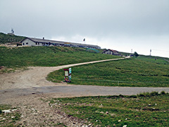
| How to get there | This is a one-way climb for road cyclists and the asphalt road ends just at the pass and Malga Mariech (restaurant/agriturismo). It is a quite nice road from Valdobbiadene Est (272m) with great views over the plain down toward Venice higher up. The climb is never very steep, but if you chose a short-cut up from the piazza in Valdobbiadene (251m) it should be steep up to the church (Santuario San Floriano) where you meet the normal road. It is also a bit steeper again after a short descent in the “wrong” direction along the mountain up to Monte Barbaria, where you have the best views a bit before reaching the pass. | |
| Other comments | A nice area with many nice climbs to explore like the Passo Praderadego (914m). There is an alternative road here starting east of Valdobbiadene, but has a somewhat long descent before it meets the normal road to the mountain, so did not include it, but it looks like a very scenic alternative (a road that could take you to an alternative pass by the Rifugio Posa Puner, maybe called Passo Federa or Passo Puner (1320m)? (the last stretch up there may be gravel road)). [IT-TV-1502] |
|
| Map |
||