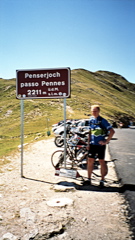
Sign 2211m
1920m - 46.8 km (Bolzano/Bozen (west))
1249m - 29.5 km (Sarnthein/Sarentino)
1270m - 15.8 km (Sterzing/Vipiteno)
[IT-BZ-2215, BIG 701]
 |
Height | Climbing height |
| 2213m Sign 2211m |
1953m - 48 km (Bolzano/Bozen (east)) 1920m - 46.8 km (Bolzano/Bozen (west)) 1249m - 29.5 km (Sarnthein/Sarentino) 1270m - 15.8 km (Sterzing/Vipiteno) |
|
| Difficulty | Beauty | |
| South 2-3 (5); North 3-4 (5) | 3-4 (5) | |
| How to get there | From the south the climb starts at Bolzano/Bozen (west) (293m) or in Bolzano (east) (266m). It is a very gradual climb for a long stretch, but it should be a nice climb (or descent) from Bolzano passing by many castles and through many tunnels. I have myself only climbed from Sarnthein/Sarentino (964m) and it is almost flat from there via Astfeld/Campolasta (1020m) until Weißenbach/Riobianco (1330m) where the final climb starts. Here it is steep, but not very steep. The difficult side to climb starts from outside Sterzing/Vipiteno (943m) in the north. It is evenly steep (around 8.5%) all the way and it is a long climb. | |
| Other comments | The pastoral valley of Sarntal and Penser Tal is very enjoyable. Views are fine from the top of the pass as well. There is water on the way on the south side, but probably not on the north side. I found good accomodation just outside Sterzing in the direction of Pfitscher Joch/Passo di Vizze (2249m) at Wiesen. You will likely also find accomodation in Sarnthein and Astfeld to the south (and in Bolzano of course). [IT-BZ-2215, BIG 701] |
|
| Map |
||