797m - 26.2 km (Briançon (north))
1340m - 38.4 km (Bourg d’Oisans)
1229m - 27.7 km (Le Freney)
1013m - 24.8 km (Barrage du Chambon)
[FR-05-2057]
|
Height | Climbing height - length |
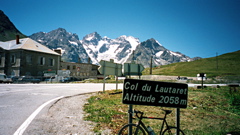
| 2057m |
853m - 27.8 km (Briançon) 797m - 26.2 km (Briançon (north)) 1340m - 38.4 km (Bourg d’Oisans) 1229m - 27.7 km (Le Freney) 1013m - 24.8 km (Barrage du Chambon) |
|
| Difficulty | Beauty | |
| West 2-3 (5); East 2 (5) | 3 (5) | |
| How to get there | It is uphill all the way from Grenoble, but first after Bourg d’Oisans (717m) the road begins to climb more like a mountain road. You start at the big (dam) Barrage du Chambon (1044m) if coming down from Col de Sarenne or Col de l’Alpe (1655m) (Les Deux Alpes). Or you could start a little before at Le Freney-d’Oisans (828m) if coming down from Alpe d’Huez via the balcony road gong to Le Freney. The eastern climb starts in Briançon (1204m or 1260m) and is almost flat for many kilometres, but after Le Monêtier-les-Bains (1477m) it is a more pronounced climb to the pass. There are often head-wind up this side to the pass for some reason. | |
| Other comments | The nicest part of the climb is by the Chambon dam and the stretch around La Grave with the spectacular mountain peaks of the Ecrins massif, La Meije and others, looming high above in the sky. The main problem with this pass is the heavy, heavy traffic. There are no similarly easy passage over the French Alps into Italy if one wishes to avoid tunnels, as it is via this pass and over the Montgenevre pass, and thus there are a lot of traffic here. (Some of the traffic thankfully comes from the south and goes to Briançon via Gap and Guillestre instead.) There is water in Le Monêtier-les-Bains on the east side, which is a good place to fill up at. You could also come to this pass via the much more interesting Col du Galibier or continue to that pass. [FR-05-2057] |
|
| Map |
||