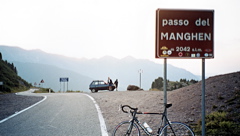
 Passo del Manghen/Manghenpass Passo del Manghen/Manghenpass |
 |
Height |
Climbing height - length |
2045m
Signs 2042m, 2047m |
1667m - 23.1 km (Scurelle)
1692m - 23 km (Castelnuovo)
1661m - 22.9 km (Borgo Valsugana)
1236m - 16 km (Molina) |
| Difficulty |
Beauty |
| 4 (5) |
2-3 (5) |
| How to get there |
This is a tough climb from both north and south. The climb from the south starts in Valsugana at Scurelle (378m) if you are coming on the small road from the east, or if arriving via the big road, Borgo Valsugana (384m) from the west or Castelnuovo (353m) from the south. It is moderately steep at first, but eventually it becomes really hard – the last 6-7 kilometres are at around 10% on average (max around 14%). The northern approach from Molina (809m) in Val di Fiemme ends with more than 8 km of similar steepness, but it is a slightly shorter climb. |
| Other comments |
This pass feels like cycling on a remote forestry road as it is mostly a narrow road through woods on both sides of the pass. There are decent views from the pass itself. It is a bit nice on the south side, which is somewhat varying, with occasional views across the valley toward the road up to Passo Cinque Croci (which is only a path higher up). There is a good place for lodging and dinner just a few hundred metres before you come down to Molina on the north side. Telve probably have some lodging on the south side. This is the most southern paved pass above 2000 m in the Dolomites.
[IT-TN-2042, BIG 707] |
Map
|
|
