479m - 6.7 km (Paneveggio); 1002m - 20.1 km (Predazzo)
[IT-BL-2030a]
|
Height | Climbing height - length |
| 2033m | 627m - 7.1 km (Falcade Alto); 1263m - 19.7 km (Cencenighe Agordino) 479m - 6.7 km (Paneveggio); 1002m - 20.1 km (Predazzo) |
|
| Difficulty | Beauty | |
| 3 (5); East (long) 4 (5) | 3-4 (5) | |
| How to get there | From the east you start just above Falcade/Falciade (1406m), when coming down from Passo di San Pellegrino/Pas de Sèn Pelegrin (1919m) and climb steeply up to the pass. It will be a longer climb if you begin down in the Agordino valley at Cencenighe Agordino (770m). The other approach starts from the west just after Paneveggio (1554m), where the main road goes straight ahead to Passo di Rolle (1971m). This is a somewhat steep climb, but it is not long and not as steep as on the east side. One can also start down in Predazzo (1031m) for a longer climb on this side. | |
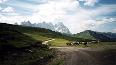
| Other comments | At the pass height (on the east side) a little gravel road (that looks bad, but is not so bad) can take you up to a higher pass in 2.9 km from where you will have much better views – Forcella di Pradazzo (2225m). The photo is taken on this gravel road. Lower down, before coming down to the Passo di Rolle road on the west side, a gravel road takes off up to Passo della Costazza/Baita Segantini (2181m). Even though this road is more prominently featured on maps than the previous mentioned road, this one is not cyclable with a road bike for ca. 2 km kilometres (on the north side) (2003). However, you can get to this pass by starting just below the pass height of Passo di Rolle, on which side the gravel road (also 2.9 km) is in a very good state. Falcade probably has lodging and one could stay at the rifugio by the pass. Water is found at the pass. [IT-BL-2030a] |
|
| Map |
||