Sign 2000m
1571m - 25.3 km (L’Isère valley (east))
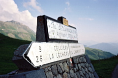
1557m - 20.7 km (La Chambre (west))
1560m - 20.2 km (Le Chambre (west) via Montgellafrey)
1543m - 19.6 km (La Chambre (east))
1543m - 20.1 km (Le Chambre (east) via Montgellafrey)
This is one of the more well-known of the French mountain passes, much because of the frequent visits by the Tour de France over the years. It is almost like an archetypical mountain pass, with almost equally long hard climbs from each side culminating with the summit which is located between high mountain peaks – these are also almost equally high on each side. The north climb has a slightly lower average gradient but is more irregular and therefore ultimately the harder side to climb.
From the south the climb starts in La Chambre. The ordinary climb starts in the centre of the village, but the shortest roads are shown in the map below from La Chambre (west) (435m) and La Chambre (east) (448m). The climb via Montgellafrey is a nice and quiet alternative that I think is generally preferable. It has some nice views early on that the regular climb does not really offer. It is also steeper early on and a little easier for some kilometres before meeting the other road at Longchamp (just before going out on the main you should go up among the hotels to meet the main road above the buildings). The climb from the north starts at 422m if coming down the l’Isère valley from the east or from 411m if coming up from the west.
The valleys are nice on both sides. There is a bar at the pass. There used to be an alternative road on the south side via Doucy, but it was so utterly destroyed in a landslide that it is not likely to ever open again. I discovered that there can be insects giving you real pain on the north side – I was attacked in good speed down and had a swollen leg for two weeks afterwards.
There is an odd, but interesting way to get to the pass from the south by going from near Saint-Jean-de-Maurienne (Pontamafrey) over the Col du Chaussy (1534m). The serpentines up through Montvernier are fantastic and one could get up via another nice approach road too (via Le Châtel). It is 13.9 km to Col du Chaussy and then another 24.7 km to Col de la Madeleine for a combined 38.6 km climb (1036m + 1145m = 2181m), which makes it a very long climb. (One could possibly continue straight ahead on a gravel road to Longchamp from Bonvillard to avoid the long descent to the Madeleine road, but the gravel road might be too difficult and long with a road bike (paved to 1646m)) There is now asphalt to 2001m height at the pass (parking).
[FR-73-1993, BIG 280]