High point of gravel road 2004m
554m - 8.1 km (Gemärk-Schluderbach/Cartonin)
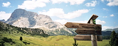
The pass road is only fully surfaced from the north. The northern climb starts east of Welsberg/Monguelfo (1117m), where a small road takes off up the Pragstal/Val di Braies. Soon you will take left and after some kilometres a paved forestry road goes nicely and easily in serpentines to the pass. There is only a short steep ramp just as you reach the pass. The road only continues as a gravel road after the pass and you even have to lift your bicycle over a cattle fence. The road is flat for approximately 2-3 kilometres on the nice plateau and here it is easy to use with a road bike, but there are many people walking here on fine days.
The road up from the south starts in Schluderbach/Cartonin (1450m) and is not too obvious as it is only a small forestry road that is closed off at start, but you can pass by. After a couple of kilometres with very varying (in quality) gravelled forest road, you suddenly will find approximately 1.5 kilometre of fine asphalt road right there. The last part up to the plateau before the pass is very rough and you are likely to have to walk there and a few other short parts with a road bike.
[IT-BZ-1993]