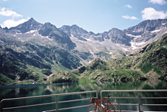
This climb is in the south of Piemonte and starts just after Valdieri (805m), where you take off toward Entracque. You do not have to go through Entracque, but can soon choose a more direct (and better) road toward Lago della Rověna (1532m). This is nice and sweet at first, but after passing a first dam you are given the choice of two narrow roads. Take the one to the right. It is quite steep most of the way to the Rovina lake and it continues steep thereafter on a restricted and private road. Supposing you do not have a mountain bike, this is the only possible road to take. It is owned by the electrical company (ENEL) that operates the dam above and they may not like that you make use of that road!
You have to go under a turnpike and then be careful with the drainage gullies as they are of the dangerous variety. At another crossroad (the road is very good until here) take the one in the direction of the huge dam wall you have seen for a long time above the Rovina lake. Then you will encounter a tunnel which is closed, but if you are lucky the door is open and it is lit. (I would not try and call on ENEL to open it (they have such a device)). The tunnel, even if lit, is quite scary, wet etc. At the end of the tunnel go straight and get out of it! After a short while you are at the highest dam where you see Rifugio Genova at the other side (reachable via a popular walking path). You are in the proximity of the pass here (it is supposedly a bit on the way over to the track going up to Rifugio Genova). Same way back!
[IT-CN-1980]