1591m (Siguret)
A good and wide road of impeccable quality (recently rebuilt with EU money) starts just below Guillestre and goes to the ski resort Risoul (1915m highest asphalted point). Get a map of the area from the tourist information, but do not ask them for advice (tourist information centres are only for family activities, I presume). The map is still not very helpful though and I had to ask an old man about the proper road up. You should turn right after the tourist centre and then right again and then stay close to the ski lift. There are many road choices, but if you choose the best looking gravel road all the time you should not have any problem reaching Col de la Valbelle (2381m).
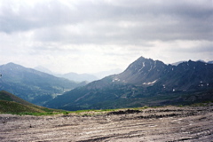
Just before reaching that pass, you could go left and get to nearby Col de Chérine (2270m). At Col de la Valbelle, there is a bad looking gravel road going steeply up to the right, which is fine after the first steep ramp. You soon reach the pass, but this is rather uneventful and you should proceed to the end of the good gravel road at Col de Saluces (2444m), only a few hundred meters further on, from where both photos up here were taken.
The road starting in Siguret (875m) down the road from Guillestre to Embrun is very nice and eventually rather steep up to Col de la Coche (1791m), where the tarmac ends. Turn left up on the forestry road. This road eventually becomes very bad (R1-2) as it leaves the wood and could not be cycled in all places (I had to take off the shoes and wade through a water shed/river at one place). If going down this way, look out for the drainage gullies on the asphalt road down from Col de la Coche.
[FR-05-2466b]