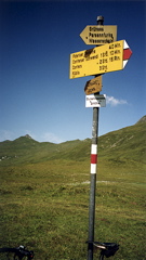
Sign 2117m
1313m (Küblis)
[CH-GR-2117a]
|
Height | Climbing height |
| 2128m Sign 2117m |
1533m (Chur); 1835m (Chur via Tschiertschen); 751m (Langwies) 1313m (Küblis) |
|
| Difficulty | Beauty | |
| 4 (5) | 3-4 (5) | |
| How to get there | It is a very nice and hard climb from Chur (595m). You can either take the ordinary road to Arosa and turn off at Langwies (1377m) (in the village -- sign for Pirgen and Fondei) or you can climb via Tschiertschen (1343m) and up from Molinis (1041m) to Langwies. The road up from Langwies is at first steep and tarmacced. At a junction go left up among trees on a not so good unsurfaced (but cyclable) road to Strassberg (1919m) (with some asphalt higher up). Soon after Strassberg the road becomes difficult to cycle on and after the last house ends. The path to and over the pass is easy (if you follow the jeep track) and is sometimes cyclable even with a road bike. From the highest point you see the real pass sign. At Obersäss (2054m) (a farm) a very rough gravel road starts down to Conters (1110m) where you find a tarmacced road down to Küblis (815m) on the road up to Davos. The gravel road improves after just a kilometer, but is still a bit hard to cycle on with a road bike, especially as it gets steeper later on. R1: to Strassberg. R1-2 to pass and to farm. R1 (rough) down to Conters. Pass sign is 4 m lower than the highest point. | |
| Other comments | You have a good view up in the direction of the Durannapass from Tschiertschen if you decide to take that very nice road (there were perhaps 20 m gravel road down to Molinis). If going up from Küblis (which will be hard) you just strike off uphill from the farm (it might not be too obvious where the jeep track is until you get 100-200 m from the farm. [CH-GR-2117a] |
|