1513m - 24.34 km - 6.2% (Vizille)
1383m - 18.69 km - 7.4% (Uriage-les-Bains)
1559m - 25.60 km - 6.1% (Gières)
1572m - 28.86 km - 5.5% (Murianette)
1548m - 27.58 km - 5.6% (Domène)
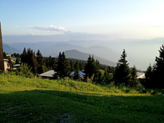
The climb to Chamrousse is rather unexciting from my memory. There are some nice views on the descent on the north side, but otherwise it is not scenic and with a boring ski resort at the top. The climb is not very steep either. This is however a classic because it has been featured in the Tour de France a couple of times and it does have merit if you climb it from Séchilienne (364m) where it is 9.8% for 9.25 km up to Col du Luitel (1267m). That part is a tough climb on a nice narrow road and one of the harder in France. The road is then flat until it reaches the boring, but good, main road to Chamrousse.
You can climb from other places like Vizille (281m) and by-pass Uriage-les-Bains (411m), where you would start if coming here from other directions. You could also start down in Gières (235m) not far from the centre of Grenoble and come up the same southern side (I drew the route up some short-cuts to the main road to make these climbs slightly steeper and shorter). For climbing up the north side one does best starting either in Murianette (222m) with the most height metres or in Domène (246m) (to where I descened after staying the night at a good hotel at the crossroad/pass(?) at Les Seiglières).
[FR-38-1262, BIG 289]