The climb to Grosse Oscheniksee is regarded as one of the hardest climbs in all of the Alps. The climb up the Mölltaler Gletscherstrasse to Hochwurtenspeicher is only slightly easier. Just look at salite.ch, where the Weisssee is the climb to the Hochwurtenspeicher, but the climbs goes to the later higher see, so there should be even some more points for this climb.
The road is nice and easy from Ausserfragant (722m) to Innerfragant where it starts to become a little steep. Just after Innerfragant (at 1172m) there is an unsignalled small asphalt road going off into the woods (you really have to look for it not to miss it). This is the road to the dam of the Oscheniksee. This road is constantly very steep and can have some debris on the ground. However, despite the steepness it is not as terribly hard a climb as one would have suspected as it is rather even and mostly around 13-15%, so it is still possible even you take your time and do not get exhausted early on. There is a shorter flatter section higher up, but it is mostly above 10% all the time to the top at 2394m.
As great a climb as the Oscheniksee might be, the Mölltaler road is much nicer and especially so higher up. Soon after the turn-off for the Oscheniksee one comes to a lift taking people up the valley and there is a bar across the road preventing motorised vehicles from trying to get up any further. You can continue on the bicycle though up though the woods on nice serpentines, rather steeply but on a wider road than to Oscheniksee.
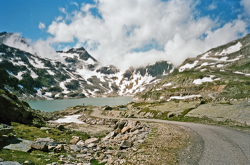
Eventually you come to a tunnel and on the other side there the road descends (1689m to 1665m) and there might be road work here around (apparently it has been problematic to get up here for some years, but hopefully (!) the road is fine now) (I were here in 2008 and another guy in 2012 and both of us got up there). Now comes a very steep section on a narrower road above 15%. Then you reach a crossroad at Zirmriegel (2126m) from where the road descends again (to 2082m) and you go through galleries and there could be some water across the road here. When you think you are there as you see some ski buildings, you still have the last impressive section to go up the Weisssee and then a little above the Hochwurtenspeicher. There asphalt road ends after another short descent and you can see a very steep gravel track winding its way up to Duisburger Hütte and Eisseehaus (that road looked a bit too bad for a road bike).
[BIG 628]