1003m - 14.9 km (Manant)
1355m - 30.65 km (Albertville)
128m - 4.59 km (Col de Méraillet)
[FR-73-1703]
 |
Height | Climbing height - length |
| 1703m | 965m - 12.2 km (Beaufort) 1003m - 14.9 km (Manant) 1355m - 30.65 km (Albertville) 128m - 4.59 km (Col de Méraillet) |
|
| Difficulty | Beauty | |
| North 3-4 (5); East 1 (5) | 5 (5) | |
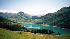
| How to get there | The climb starts to the north in Beaufort (740m) (or just below at Manant (700m)) and goes via the nice village of Arêches (1055m). It is up all the way from Albertville (346m). Just after Arêches you take left up a quite steep and narrow road to the pass. Just after the pass you get very good views first of the Mont Blanc mountains and then also of the Lac de Roselend. This is the nicest approach to the (Col du) Cormet de Roselend (1969m) pass. The climb up from the dam and the crossroad at Col de Méraillet (1607m) is short and easy. | |
| Other comments | This and Cormet de Roselend are among the most beautiful pass roads in the French Alps. An alternative pass road over the Beaufortin mountains is the Col du Cormet d’Arêches (2106m) pass which is just about cyclable with a road bike (one goes straight on up the valley from Arêches instead of going over the Col du Pré if coming from Beaufort). The Cormet d’Arêches has around 6 km gravel road and is a bit difficult on the south side and it is also rather steep on the asphalt part up from Granier. There is a grocery shop in Arêches. [FR-73-1703] |
|
| Map |
||