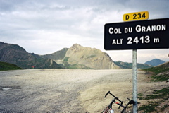
Sign 2413m
[FR-05-2404, BIG 292]
|
Height | Climbing height - length |
| 2405m Sign 2413m |
1038m - 11.1 km (Chantemerle) | |
| Difficulty | Beauty | |
| 4 (5) | 3 (5) | |
| How to get there | The climb starts just a few kilometres outside Briançon in the direction of Col de Lautaret (2057m) at Chantemerle (1367m). There is no sign and there are two possible roads to follow up to Villard-Laté (one steep straight short-cut and the regular road). But if you go up you are likely on the right road. From Villard-Laté to the pass it is almost always quite steep, though never extremely steep. Maximum is around 14%. The road actually continues down to a place called Granon, on the other side of Briançon, but it is an unpaved road that should be a bit too rough here and there with a road bike (it looked quite okay at the start after the pass height though, but the steeper passages lower down are probably no good). | |
| Other comments | Bring water with you as there is none on this climb. The road is very exposed to the sun and Briançon brags about having at least 300 sunny days per year. There is a military area around the top region and some signs announce this. There are some rough roads that could be explored in order to visit some rough-stuff passes nearby. Col de la Cibières (2525m) (R1-2) in the rough-stuff section is one such pass (the road there was very bad – maybe the road to Col de Barteaux (2382m) in the other direction is better). (The map below also shows the Lautaret-Galibier climb.) [FR-05-2404, BIG 292] |
|
| Map |
||