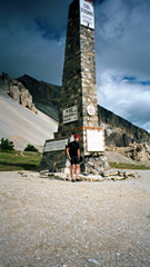
1382m - 30.7 km (Guillestre)
1523m - 34.5 km (Guillestre N94)
1149m - 19.1 km (Briançon)
The south side is dramatically different from the north side of this pass and as many have said this pass is good for separating the South French Alps from the Northern Alps. Here you can experience both worlds on the same climb. However, the northern Alps are usually much nicer than this north side and the south side is exceptionally beautiful among the southern passes. The Casse Deserte – the strange, coulorful and stony landscape on the higher reaches of the south side is a major tourist attraction. It is very hard to understand the proportions because it looks as if the mountainside has all slided down with some rocks an trees still standing here and there. The road descends a little here on the south climb and is the location for an obscure pass – Col de la Platrière (2212m).
This “slided” landscape continues all the way up to the pass itself. See the profile for the Briançon side and for the south side. There are two minor passes located on either side of where the road on the south side starts at Château-Queyras: Col de l’Ange Gardien (1347m), which you pass by coming from Guillestre and Le Collet/Coulet (1387m), which you pass over if coming down from Col Agnel/Colle dell’Agnello (2744m) (see this for more information).
On the north side you could turn off the road after a while and climb the military road to Col des Gondrans (2347m), which is a marvellous climb (on a bad asphalted military road 12.4 km from the Izoard road) and is much more interesting than the north side of the Izoard pass. You can also take of at Cervières (1612m) to climb up the side valley to Les Fonts/Fonds (2047m), but this road is partly gravelled.
[FR-05-2360, BIG 294]