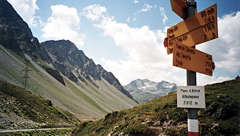
Signs 2315m, 2312m
1526m - 30.2 km (Tiefencastel)
1369m - 24.7 km (Alvaneu Bad)
[CH-GR-2312, BIG 596]
|
Height | Climbing height - length |
| 2312m Signs 2315m, 2312m |
632m - 9.12 km; 6.95% (La Punt) 1526m - 30.2 km (Tiefencastel) 1369m - 24.7 km (Alvaneu Bad) |
|
| Difficulty | Beauty | |
| 3 (5) South; 4 (5) North | 4-5 (5) | |
| How to get there | From the south one start at La Punt (1687m) in the Engadin valley. The climb is somewhat steep on the north side with 6 kilometres at around 9%. The climb from Tiefencastel (851m) on the north side is quite a different story and is a very hard climb. It is a very irregular climb on a narrow road and has steep stretches of up to 14%. The climb really starts in Alvaneu Bad/Alvagni Bogn (945m). | |
| Other comments | This is the nicest and most beautiful of the passes into/out of the Engadin valley. There is a train going up this pass on the north side, but it goes through a tunnel after circling around and trying to get as high as possible before entering the tunnel at Preda (1789m), but then does not go under the pass and ends up in another valley (Val Bever) on the other side rather than the Val d’Alvra one descends to La Punt on the bicycle. There is water in Bergün/Bravuogn (1367m) on the way up on the north side. It is a pass mostly popular with tourists and traffic is seldom a problem here. I recommend climbing the north side as it is much nicer and more interesting. The pass height has a look not unlike the parallel Flüelapass/Pass dal Flüela (2384m). (Another local name is Pass da l’Alvra.) [CH-GR-2312, BIG 596] |
|
| Map |
||