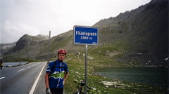
Sign 2383m
1723m - 46.4 km (Tiefencastel)
1606m - 41.4 km (Alvaneu Bad)
1495m - 41 km (Alvaneu Dorf)
824m - 13 km (Davos (Dorf))
958m - 12.8 km (Susch)
From the north the pass road starts at Davos (Dorf) (1560m). The climbing could also start further down north at Landquart (529m) for a long climb on alternative roads (as the main road is forbidden in a couple of sections, typically when it is safe enough for cycling, as usual). Coming from Landquart you will have to go through Klosters on the old road and will then pass over the Wolfgangpass (1632m) just before reaching Davos.
A nicer alternative is the start from northwest at Alvaneu Bad/Alvagni Bogn (945m) if coming from Albulapass/Pass d’Alvra (2312m); or Alvaneu Dorf/Alvagni Vitg (1056m) if coming from Lenzerheidepass/Parpaner Höhe (1550m); or Tiefencastel/Casti (852m) if coming from the Julierpass/Pass dal Güglia/Passo del Giulia (2284m). This climb goes via Davos Wiesen (1437m) and then down to the Bärentritt tunnel (1269m) (perhaps possible to avoid by using a gravel road, but maybe not the best of gravel roads (have not tried it)).
From the south one starts in the Unter-Engadin village of Susch (1426m). The climb is steeper on the south side, but also shorter. Despite being one of the best pass roads into the Engadin valley it is not so very trafficated. Actually it is mostly uphill all the way from Innsbruck on the southeast side of the pass.
[CH-GR-2383a, BIG 594]