161m (Passo del San Gottardo/St. Gotthardpass)
Cycling from Valle (1116m) just south of Airolo to this pass with a road bike is not possible. The road is only paved in parts and some parts are nearly not traceable in the grassy meadows and one ramp is a very steep and rough jeep track and another section is a steep gravelled asphalt road with bends! Yet other parts just below the pass have a nice surface. See the map below for the road (in red) I think I was travelling, but it cannot even be traced on satellite maps and surely not on any maps.
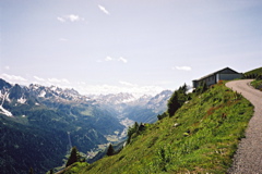
The “south” rating for difficulty is if you climb via Airolo (1156m) and the Passo del San Gottardo/St. Gotthardpass/Son Gottard/Col du St-Gothard (2107m). At tiny tarmacced road leads of in the direction of a higher dam (Lago della Sella) from the hospice/museum on the east side of the little lake near the Passo del San Gottardo/St. Gotthardpass. After a short while you reach Bassa della Sella (2138m) where there is a directional sign for Passo Scimfuss. You take right and suddenly it seems like it is only a rough road ahead, but it is only unpaved (R1) for 100 metres (in 2004) and is not a problem. Then there is good asphalt over the pass (which is neither signed nor geographically distinct). For a really long climb one starts already down in Biasca (296m).
[CH-TI-2238]